
The following is transcribed from Bullitt County Will Book F, pages 377-380. Note that processioning was a legal term for dividing up land by virtue of a court-appointed committee. Those assigned to the task were called processioners which is misspelled as "possessioners" in this document. Also, I've taken the liberty of adding useful punctuation where needed.
[beginning of document]
page 377:
Bullitt County Court
We the undersigned Possessioners of Bullitt County, being called on by the citizens of Pittstown for the purpose of possessioning and establishing the lines and corners of the streets and lots of said town in order so as to enable them to know the true boundaries of their respective lots, we proceeded on the 14th day May 1858, and in conjunction with the surveyor of Bullitt County, and made a resurvey of said Pitts Town made out by Whitledge Overall formerly Surveyor of this county, and after making said resurvey we by mutual agreement planted a large stone at A on
page 378:
plat as the stationary, and established South East and Beginning corner of said Pitts Town; after which we again proceeded and began at the stone above named and laid off all the streets, alleys and lots as shown and laid down on the within plat, and planted a stone at each corner of said streets, alleys and lots. Herewith we give the boundary of said Pitts Town. Beginning at a large stone at A, South East corner of said town, thence N 44 W 1047 feet to B, thence S 46 W 396 feet to C, thence S 44 E 1047 feet to D, thence N 44 E 396 feet to the Beginning containing
References
Rolling Fork Street is 33 feet wide and 1014 feet long and extends the whole length of the town.
Main Street is 33 feet wide and 639 feet long.
Triangular Street begins at the corners of Lots No. 6 & 23 and extends to Salt River Street and is 33 feet wide and 375 feet long and N 51 degrees 43 minutes W for 52 degrees.
Clay & Hardin Streets are each 33 feet wide and 363 feet long.
Buck & Kentucky Alleys are each 12 feet wide and 363 feet long.
All lots between 6 & 14 are 66 feet wide and 120 feet deep.
The lots between 15 & 23 are each 66 feet wide and 210 feet deep.
The width and depth of the remaining lots see the distances marked on the within plat.
The within report is respectfully submitted to the court for record.
James Combs
Peter Troutman
Casper Herps, Surveyor for Bullitt County
page 379:
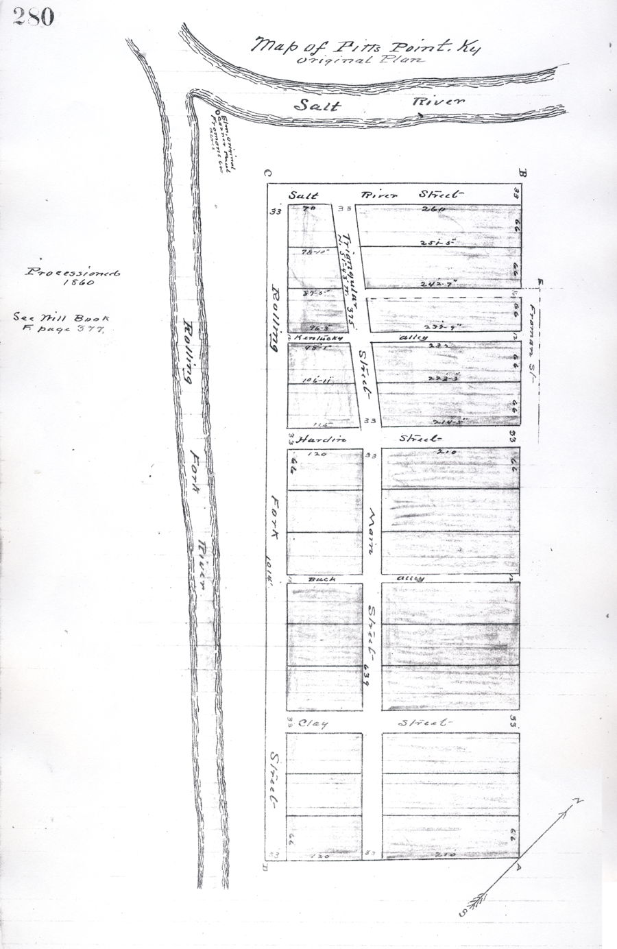
[Plat, shown below, was drawn on this page. Note that a later version, found in the T. C. Carroll Plat Cabinet as Slide 66, Map 280, is shown at the bottom of this page.]
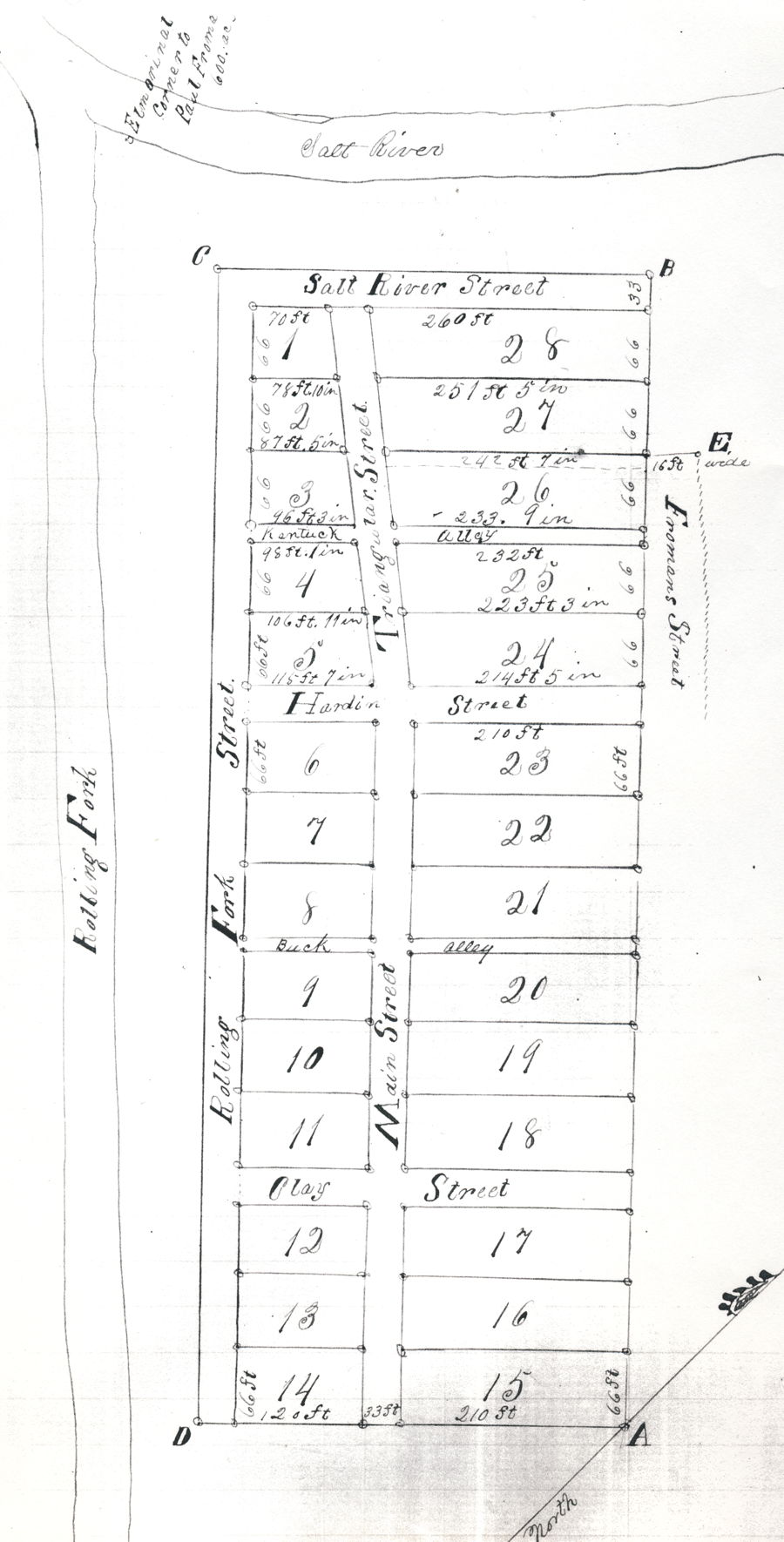
References continued
The line between Salt River Street & Lot No. 1 is 70 feet.
The line between Lots 1 & 2 is 78 feet, 10 inches.
The line between Lots 2 & 3 is 87 feet, 5 inches.
The line between Kentucky Alley & Lot No. 3 is 96 feet, 3 inches.
The line between Kentucky Alley & Lot No. 4 is 98 feet, 1 inch.
The line between Lots 4 & 5 is 106 feet, 11 inches.
The line between Hardin Street & Lot No. 5 is 115 feet, 7 inches.
The line between Hardin Street & Lot 24 is 214 feet, 5 inches.
The line between Lots No. 24 & 25 is 223 feet, 3 inches.
The line between Kentucky Alley & Lot 25 is 232 feet.
page 380:
The line between Kentucky Alley and Lot 26 is 233 feet, 9 inches.
The line between Lots No. 26 & 27 is 242 feet, 7 inches.
The line between Lots No. 27 & 28 is 251 feet, 5 inches.
The line between Salt River Street & Lot 28 is 260 feet.
The bearring of Triangular Street is N 51 degrees 43 minutes W formerly 52 degrees, which was an error in calculating the Lots by N 52 W it will make Lot No. 1 where it joins Salt River Street only 68 feet should be 70 feet.
It appears that in resurveying said town that John Greenwell, now a citizen, has built a house on Kentucky Alley between the Lots No. 25 & 26 and it was agreed between said John Greenwell and all the citizens of said Pitts Town that the said John Greenwell is to give an Alley 16 feet wide as laid down on the within plat running through Lot No. 26 and is to extend the line between Nots 26 & 27 44 feet to E. in order so as to give to said citizens an outlet or passage up Fromans Street, a street given by Jerry V. Froman to the citizens. We hereby report that the alley above named we laid off the same and planted stones at every corner according to directions of the parties.
State of Kentucky
County of Bullitt
I, Robert F. Samuels, clerk of the County Court for the county aforesaid do certify that on the 20th day of February 1860, the foregoing plan of Pitts Town was produced in open court for record and no exceptions being had, thereto the same was examined and approved of and ordered to be recorded which with this certificate is truly done in my office.
R. F. Samuels, Clerk
by J. W. Stoner, Deputy Clerk
[end of document]
If you, the reader, have an interest in any particular part of our county history, and wish to contribute to this effort, use the form on our Contact Us page to send us your comments about this, or any Bullitt County History page. We welcome your comments and suggestions. If you feel that we have misspoken at any point, please feel free to point this out to us.
The Bullitt County History Museum, a service of the Bullitt County Genealogical Society, is located in the county courthouse at 300 South Buckman Street (Highway 61) in Shepherdsville, Kentucky. The museum, along with its research room, is open 10 a.m. to 4 p.m. Monday through Friday. Saturday appointments are available by calling 502-921-0161 during our regular weekday hours. Admission is free. The museum, as part of the Bullitt County Genealogical Society, is a 501(c)3 tax exempt organization and is classified as a 509(a)2 public charity. Contributions and bequests are deductible under section 2055, 2106, or 2522 of the Internal Revenue Code. Page last modified: 12 Jan 2024 . Page URL: bullittcountyhistory.org/bchistory/pp1858plat.html