The following article by Charles Hartley originally appeared in The Pioneer News on 13 Nov 2023.
It is archived here for your reading enjoyment.
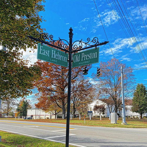
Picture yourself on the northwest corner of the intersection of Hebron Lane and Old Preston Highway. Behind you is a retail complex called the Hebron Building, and as you look eastward you see a modern bank building on one corner and Hebron Cemetery on the other one. As you turn to your right the venerable Hebron Presbyterian Church comes into view.
However, transport yourself back two and a half centuries and all you will behold is a forest, for it was in that year, 1773, that Thomas Bullitt led the surveying party that first ventured up Salt River to what was to become Bullitt's Lick.
It appears that two years later, in the summer of 1775, William and Peter Casey spent time in this area, establishing their claim to Kentucky land. Apparently they sold that claim to Edward Williams, a resident of what was then Hardy County, Virginia (now West Virginia). In the early part of 1780 Williams hired Isaac Hite to come to Kentucky and claim for him a settlement of 400 acres with an adjoining 1000 acre preemption based on the Caseys' claim.
In April, Williams obtained a Virginia Treasury Warrant for the land, but it was not until 1784 that his claim was actually surveyed by Benjamin Patton who laid out the 400 acre settlement and adjoining 1000 acre preemption. These two tracts that would lie southeast of Brooks' Spring, and north of land claimed later by Robert Shanklin.
The present-day intersection where I asked you to picture yourself lay within Williams' land.
In 1794, Williams sold the southern part of his two tracts, to Isaac Hornbeck who, in 1799, deeded the southeast corner of this land to his son Samuel. Then a couple of months later, Isaac died, and in his will he left the remainder of his land to his sons John and Cornelius (Neal). Neal's part lay to the west of Brooks' Run, and John had the rest which included the northern side.
In December 1802, Williams sold the rest of his Bullitt County land to George Reed, a resident of Bourbon County. Reed then sold a 50 acre tract to Robert Martin located in the southeast corner of Reed's land whose boundary began at John Hornbeck's northeast corner. Almost a decade later, in 1810, Martin sold the tract to Benjamin Summers.
By the early 1820's, John Hornbeck had become indebted to Richard Ferguson and the court ordered his land sold at auction to pay the debt. John's brother Samuel was the high bidder.
At some time prior to this, or in the next decade, a lane was established that ran generally east-west and lay close along the dividing line between the Hornbeck and Reed tracts. This lane was likely established to give folks to the east access to the old road from Shepherdsville to Louisville.
This lane is referenced in an 1831 deed in which Benjamin Summers sold one acre to the county, represented by its justices of the peace Rudolphus Bukey, Jesse Willson, Jacob Peacock, George Hedges, Henry C. M. Cartmell, Nathaniel P. Saunders, Henry H. Samuels, William Hill, Henry F. Kalfus, Thomas Shain, William W. McCroskey, John Graham, Henry Small and Wilford Lee.
According to the deed, Benjamin Summers, John C. Shanklin, Abner Gore, Joseph Saunders, Thomas Wells, John Anderson, John Rowland, Joseph A. Brooks, Solomon Hornbeck, John McDowell, Robert Shanklin, Jesse Willson and others had built a school house on the lot and were deeding it to the county under an Act of Assembly passed in Frankfort in 1825.
The deed indicated that the lot began at a stone in the lane between Samuel Hornbeck and Benjamin Summers, ran up the lane westwardly with their line 297 feet, then directly northeast 396 feet to what it called "the big road leading to Louisville" and with that road southward to the beginning. The land formed a triangle in the corner of Summer's tract.
However, according to a writing prepared by Martha Balee, great-granddaughter of Benjamin and Volinda (Beckwith) Summers, the first school built on this site was constructed by Volinda's father John Beckwith. She wrote that it was built on a triangular tract of land "bound on the east by what is now highway No. 61 and on the south by Hebron Lane."
According to Mrs. Balee, the first schoolhouse was of brick, and was replaced twice later with frame buildings. She indicated that the last school there was closed in 1938.
Meanwhile, back in 1831 the Kentucky General Assembly had passed an act incorporating the Shepherdsville and Louisville Turnpike Road Company. Francis Maraman, Thomas Joyce, Matthew Wilson, Abraham Field, John Burks, and Henry Robb were authorized to open books for the subscription of stock in the company. They were to construct a turnpike road on what was then called the McAdam's plan.
Around 1820, Scottish engineer John L. McAdam had developed a system of road construction using an eight inch bed of stones no larger than three inch diameters which were topped with another two inches of smaller stones no larger than three-quarter inches.
It soon became obvious that, while such quantities of stone were a challenge to obtain and transport to the road site, wood was in plentiful supply, and the idea of laying road surfaces of planks was both cheaper and easier to obtain.
The road they laid out and began constructing was undoubtedly the same as that called "the big road to Louisville" in the school deed described above.
Samuel Hornbeck died in 1835, and following a distribution of his lands to his sons, Isaac, John and Preston, those sons each sold their shares to Matthew Wilson in December 1839.
The following September, Wilson purchased another 330 acres from Basil Summers that lay east of the Hornbeck land, and he now owned land stretching from Brook's Run on the west to Cedar Creek and Floyd's Fork to the east. He also owned about 360 acres along Pennsylvania Run, a tributary of Cedar Creek.
Following Wilson's death in 1856, his heirs requested that the County Court assign commissioners to divide his land. Solomon N. Brooks, Rufus K. Summers and John Holsclaw were appointed, along with County Surveyor Casper Herps, and the land was divided into six parts. Five parts are shown on the drawing included with this article. The sixth part lay along Pennsylvania Run which flows into Cedar Creek north of this drawing.
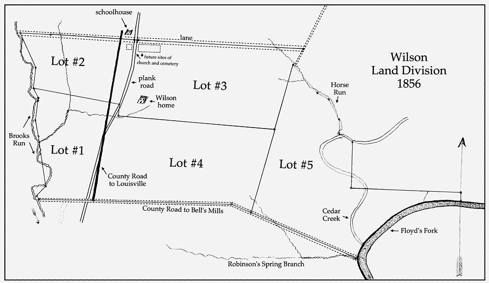
Look closely at this drawing by Casper Herps and you will see the locations of the schoolhouse and the plank road. As you can see both are located along the lane at the north of the Wilson land. Also shown is the nearby location of the older county road.
At that time a Presbyterian minister named Robert Morrison was serving as schoolmaster at the brick schoolhouse, and twice a month he held Sunday worship services there for local members of that faith including members of the Wilson family.
Not long after this, members of his small congregation began discussing the construction of a church building and two ladies, Miss Mary V. Wilson and Mrs. Ann F. Standiford were assigned the responsibility of accepting subscriptions to pay for it.
Rufus K. Summers undertook the supervision of the construction, and Miss Wilson, who had inherited Lot #2 from her father's estate, donated an acre of it across the lane from the schoolhouse for the church's location.
Construction was completed by March 1858, and the first service held in the sanctuary occurred on the 28th of that month. They named the church Hebron after the place in the Holy Land that was home to Abraham, Isaac and Jacob. According to the church history, the name Hebron meant "society, friendship and union."
While additions have been made to the building done through the years, today's congregation still worships in the original sanctuary.
It would not be long before the little lane and the schoolhouse too became known by the name Hebron.
By 1869, the idea of having a plank road had ceased to be popular, and the General Assembly passed an act turning the plank road company into the Bullitt County Turnpike Company with indications that they were expected to use rock instead of wood planks. Jilson P. Johnson was named the company president, and H. C. Crist and George C. Shanklin were the company managers.
Regarding the Wilson family, Mary V. Wilson, who donated the land for the church site, married Rev. James Newton Saunders, a Presbyterian minister in February 1869. They spent much of the remainder of their lives in Bloomfield.
Her sister Emma T. Wilson, who began with Lot #1 of her father's estate, would purchase the remainder of her sister Mary's lot #1 in 1881. Then in 1891, following the death of her brother Matthew E. Wilson, she would first purchase Mary's share of his land (Lot #3), and then split his land with the remaining siblings, ending up with 121+ acres that lay along Hebron Lane, east of the turnpike.
Before she sold her portions of Lots 1 and 2 to J. D. Robards, in 1892 she deeded an additional lot next to the church to be used for a residence for the church pastor.
Emma had one more significant contribution to make to the intersection where you imagine you are standing. In September 1894, she deeded a three acre tract to the Hebron Cemetery Company.
Prior to this time, most burials in the county took place in family plots, with the Pioneer Cemetery in Shepherdsville being the main public cemetery. However, that site was filling up, and was a frequent victim of flooding.
A better location was needed, and the residents in the northern part of the county found that the land across the turnpike from the church would make an excellent cemetery; and so it has.
So there you have it. A school, a church, a cemetery, and a road, each contributing to the history of our little intersection. Sounds like a fine place for at least one historical marker, or maybe two. What do you think?
Copyright 2023 by Charles Hartley, Shepherdsville KY. All rights are reserved. No part of the content of this page may be included in any format in any place without the written permission of the copyright holder.
The Bullitt County History Museum, a service of the Bullitt County Genealogical Society, is located in the county courthouse at 300 South Buckman Street (Highway 61) in Shepherdsville, Kentucky. The museum, along with its research room, is open 10 a.m. to 4 p.m. Monday through Friday. Saturday appointments are available by calling 502-921-0161 during our regular weekday hours. Admission is free. The museum, as part of the Bullitt County Genealogical Society, is a 501(c)3 tax exempt organization and is classified as a 509(a)2 public charity. Contributions and bequests are deductible under section 2055, 2106, or 2522 of the Internal Revenue Code. Page last modified: 13 Jan 2024 . Page URL: bullittcountyhistory.org/memories/place-marker.html