
In 1811, Joseph Aud purchased 304 acres of land along Rocky Run from Henry Crist. Aud died in 1815, and the following document describes how his widow Ann Aud's dower portion of his land was re-measured in 1831 by order of the County Court. At the bottom of this page is a map showing a rough approximation of the location of the original 304 acres.
Bullitt County Court, 19th September 1831
On the motion of Levi Magruder, ordered that Rodolphus Bukey, Whitlege Overall, James Tucker, and William F. Hilton, or any three of whom being first sworn be and they are hereby appointed commissioners to readmeasure to Ann Audd, widow of Joseph Audd dec'd, her dower in the lands of which her husband died seized and possessed in the County of Bullitt, and that the said commissioners give the said Ann Audd reasonable motice in writing of the time when and the place where they will attend to commence said admeasurement, and that the said commissioners proceed to lay off to the said Ann Audd her dower in said land and report their proceedings to the next term of this Court.
Copy Att. N. C. Summers, Clk
This day W. Overall, James Tucker and William F. Hilton personally appeared before me and made oath to comply with the requisitions of the within order, given under my hand and seal this 10th day of October 1831.
R. D. Bukey, (Judge?) B. C.
Mrs. Ann Aud, administratrix of Joseph Aud dec'd, you will please take notice that on the 10th day of October 1831, I shall attend at the house of Joseph Audd dec'd in Bullitt County with the commissioners appointed by the County Court of Bullitt, then and there readmeasure and allot to you your dower in the lands of said Aud dec'd, and shall continue from day to day till the whole is completed.
Respectfully yours,
Levi Magruder
Sept 20, 1831
Executed by leaving substantially a true copy of the within notice Sept 20, 1831.
W. W. Swearingen, C.B.C.
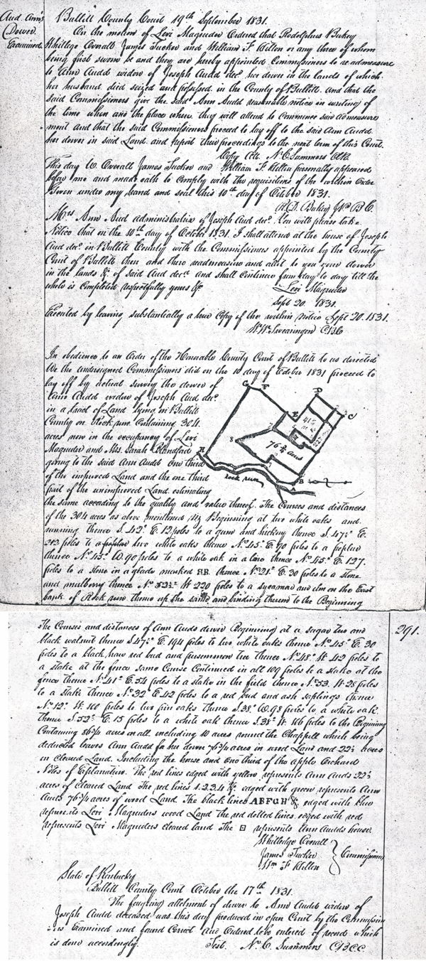
In obedience to an order of the Honorable County Court of Bullitt to us directed, we the undersigned commissioners did on the 10th day of October 1831, proceed to lay off by actual survey the dower of Ann Audd, widow of Joseph Aud dec'd, in a tract of land lying in Bullitt County on Rock Run, containing 304 acres now in the occupancy of Levi Magruder and Mrs. Sarah Blandford, giving to the said Ann Audd one third of the improved land and the one third part of the unimproved land, estimating the same according to the quality and value thereof the courses and distances of the 304 acres as above mentioned, viz Beginning at two white oaks and running thence S 42° E 12 poles to a gum and hickory, thence S 47 1/2° E 212 poles to two white oaks, thence N 45° E 90 poles to a poplar, thence N 115° W 90 poles to a white oak in a lane, thence N 45° E 127 poles to a stone in a glade marked S.B., thence N 21° E 30 poles to a stone and mulberry, thence N 52 1/2° W 220 poles to a sycamore and elm on the East bank of Rock Run, thence up the same and binding thereon to the Beginning.
The courses and distances of Ann Auds dower, Beginning at a sugar tree and black walnut, thence S 47.5° E 194 poles to two white oaks, thence N 45° E 30 poles to a black haw red bud and persimmon tree, thence N 48° W 42 poles to a stake at the fence, same course continued in all 109 poles to a stake at the fence, thence N 41° E 54 poles to a stake in the field, thence N 53° W 28 poles to a stake, thence N 32° E 42 poles to a red bud and ash saplings, thence N 12° W 100 poles to two pin oaks, thence S 38° W 98 poles to a white oak, thence S 52° E 15 poles to a white oak, thence S 38° W 116 poles to the Beginning. Containing 86 3/4 acres in all including 10 acres round the chappell which being deducted leaves Ann Audd for her dower 76 3/4 acres in wood land and 22 1/2 acres in cleared land. Including the house and one third of the apple orchard.
Notes of explanation. The red lines edged with yellow represents Ann Auds 22 1/2 acres of cleared land. The red line 1, 2, 3, 4 and edged with green represents Ann Auds 76 3/4 acres of wood land. The black lines A, B, F, G, H and edged with blue represents Levi Magruders wood land; the red dotted lines edged with red represents Levi Magruders cleared land. The [.] represents Ann Audds house.
(signed) Whitledge Overall, James Tucker, Wm. F. Hilton, Commissioners
State of Kentucky
Bullitt County Court, October the 17th 1831.
The forgoing allotment of dower to Ann Audd, widow of Joseph Audd deceased, was this day produced in open court by the commissioners, examined and found correct, and ordered to be entered of record which is done accordingly.
Test. N. C. Summers, C.B.C.C.
This map shows a rough approximation of the location of Joseph Aud's original 304 acre tract along Rocky Run, near Woodsdale Road. The "A" marker indicates where we think the original Aud house was located. The "J" marker indicates the approximate location of the St. John's Chapel located on a part of his land that he deeded to the Catholics for a church and cemetery.
If you, the reader, have an interest in any particular part of our county history, and wish to contribute to this effort, use the form on our Contact Us page to send us your comments about this, or any Bullitt County History page. We welcome your comments and suggestions. If you feel that we have misspoken at any point, please feel free to point this out to us.
The Bullitt County History Museum, a service of the Bullitt County Genealogical Society, is located in the county courthouse at 300 South Buckman Street (Highway 61) in Shepherdsville, Kentucky. The museum, along with its research room, is open 10 a.m. to 4 p.m. Monday through Friday. Saturday appointments are available by calling 502-921-0161 during our regular weekday hours. Admission is free. The museum, as part of the Bullitt County Genealogical Society, is a 501(c)3 tax exempt organization and is classified as a 509(a)2 public charity. Contributions and bequests are deductible under section 2055, 2106, or 2522 of the Internal Revenue Code. Page last modified: 12 Sep 2024 . Page URL: bullittcountyhistory.org/bchistory/annauddower.html