
The Baileys sold small parts of their Cedar Creek land to four different parties as described below.
Bullitt County Deed Book 33, pages 43-44
George T. & Julie A. Bailey and George A. & Claribel Bailey to Robert Wethers
1 July 1898; 10 acres for $100
Beginning at a stake in Hedges' line, corner to Richard Harris' 12 acre tract, thence with same N 5° E 54 poles to a stake in Bridges' line, Harris corner, thence with Bridges' line S 89°45' E 22 poles to a stake in said line and corner to Tom Boax, thence with his line S 5° W 93 poles to Hedges' line in a branch, thence up said branch with Hedges' line to the beginning.
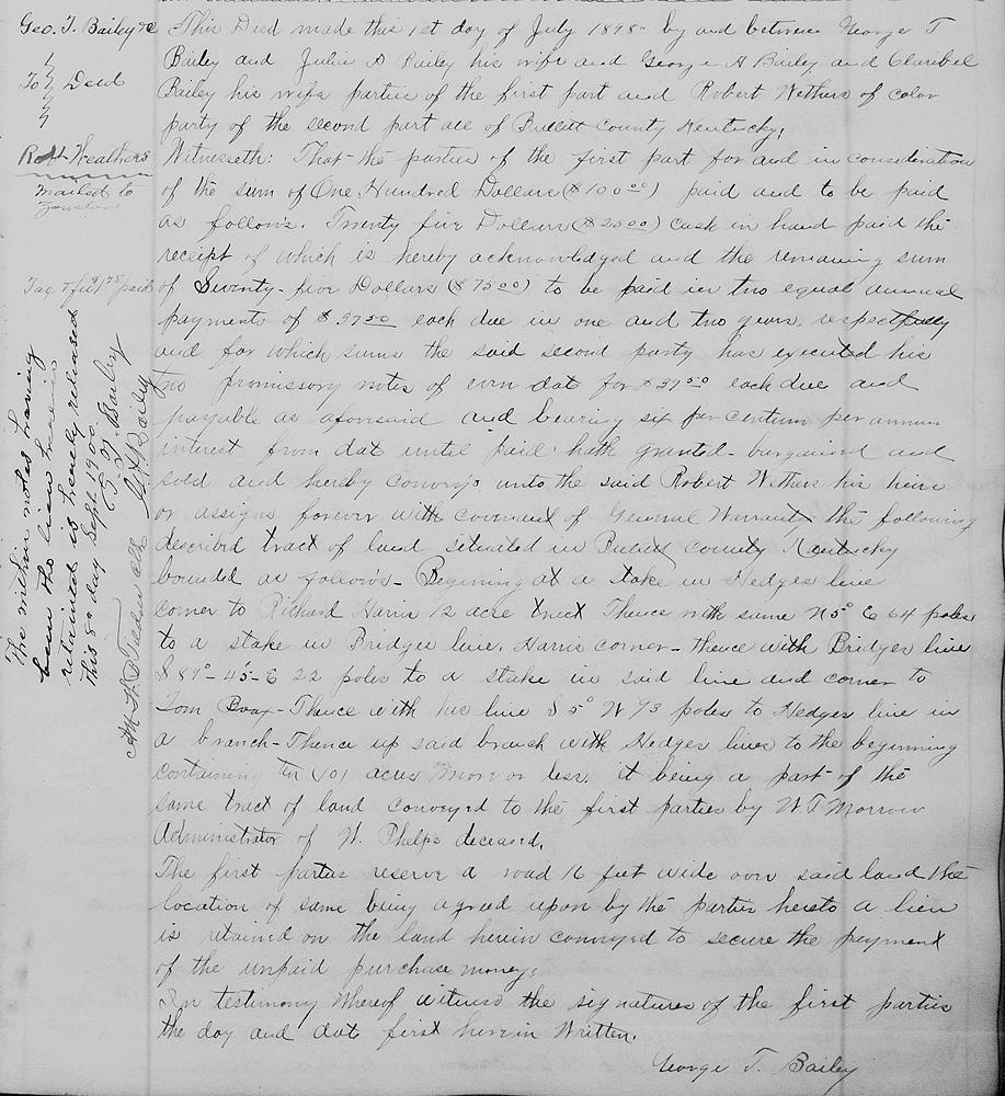
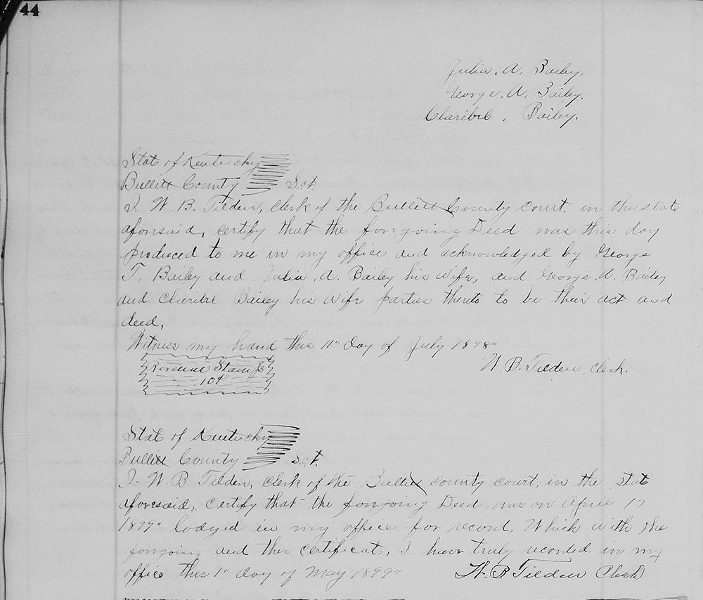
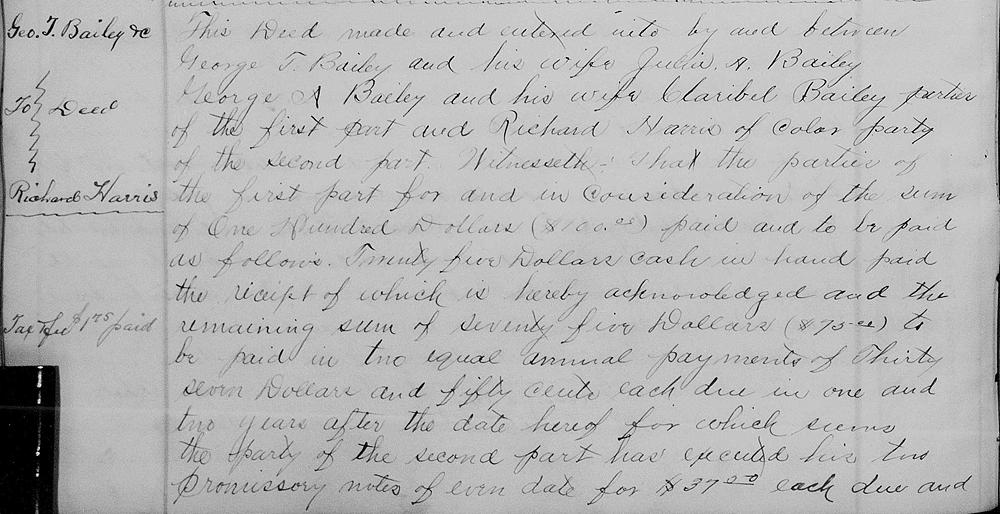
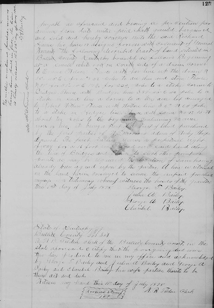
Bullitt County Deed Book 33, pages 124-125
George T. & Julie A. Bailey and George A. & Claribel Bailey to Richard Harris
1 July 1898; 12 acres for $100
Beginning at a small white oak on south side of a drain, corner to Emma Wilson, thence with her line up the drain N 38°45' E (for 41°) 56 poles to an elm and stone, thence N 39° for 37°15' E 17 3/5 for 22 2/5 poles to a stake, corner to Bridges, thence with Bridges' line S 89°45' E 40 poles to a stake in said line, a corner to a ten acre lot conveyed to Robert Wethers, thence with Wethers' line S 5° W 64 poles to a stake in Hedges' line, thence with same N 7°15' W about ten poles to the beginning.
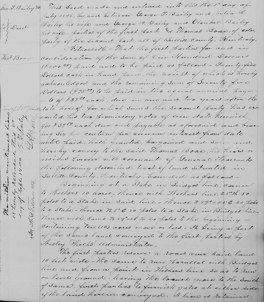
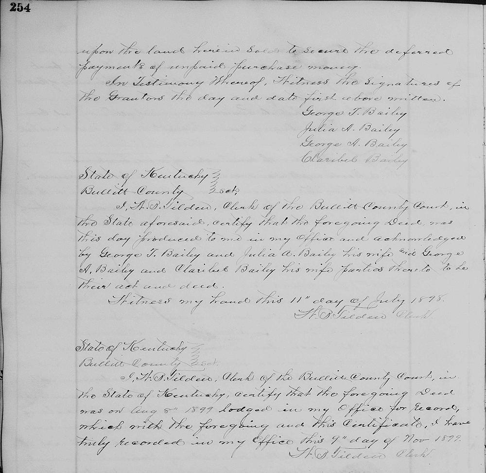
Bullitt County Deed Book 33, pages 253-254
George T. & Julie A. Bailey and George A. & Claribel Bailey to Thomas Borax
1 July 1898; 10 acres for $100
Beginning at a stake in Bridges' line, corner to Wethers' 10 acres, thence with Wethers' line S 5° W 80 poles to a stake in said line, thence S 89°45' E 20 poles to a stake, thence N 5° E 80 poles to a stake in Bridges' line, thence with same N 89°45' W 20 poles to the beginning.
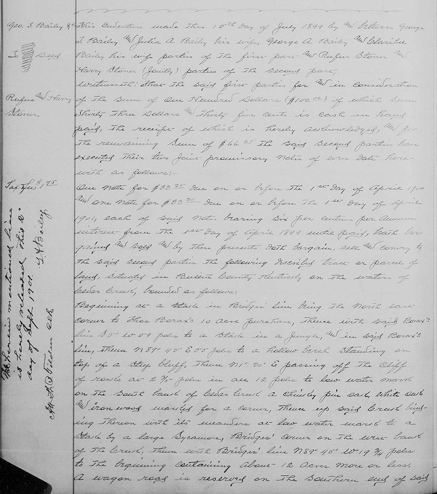
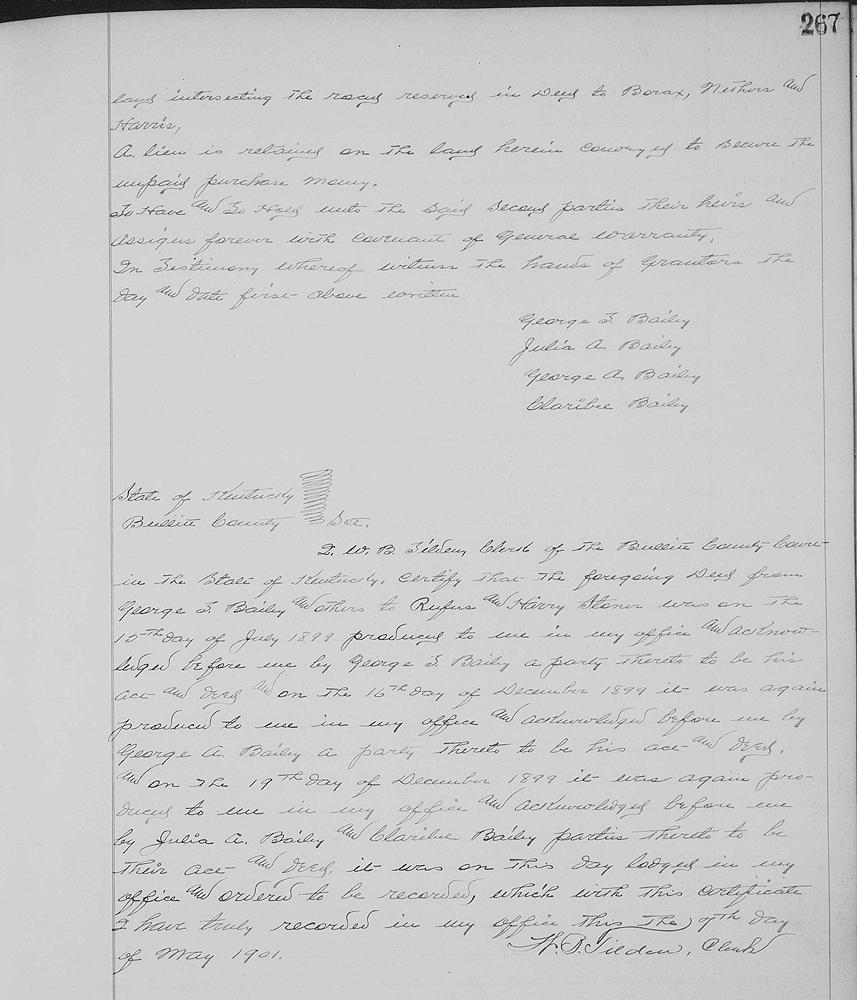
Bullitt County Deed Book 34, pages 266-267
George T. & Julie A. Bailey and George A. & Claribel Bailey to Rufus & Harry Stoner (jointly)
15 July 1899; 12 acres for $100
Beginning at a stake in Bridges' line, being the northeast corner to Thomas Borax's 10 acre purchase, thence with said Borax's line S 5° W 59 poles to a stake in a jungle, and in said Borax's line, thence N 89°45' E 55 poles to a hollow beech standing on top of as steep bluff, thence N 1°30' E passing off the cliff or rocks at 2 3/5 poles in all 12 poles to low water mark on the south bank of Cedar Creek, a chickey pin oak, white oak and ironwood marked for a corner, thence up said creek, binding thereon with its meanders at low water mark to a stake by a large sycamore, Bridges' corner on the west bank of the creek, thence with Bridges' line N 89°45' W 19 3/4 poles to the beginning.
If you, the reader, have an interest in any particular part of our county history, and wish to contribute to this effort, use the form on our Contact Us page to send us your comments about this, or any Bullitt County History page. We welcome your comments and suggestions. If you feel that we have misspoken at any point, please feel free to point this out to us.
The Bullitt County History Museum, a service of the Bullitt County Genealogical Society, is located in the county courthouse at 300 South Buckman Street (Highway 61) in Shepherdsville, Kentucky. The museum, along with its research room, is open 10 a.m. to 4 p.m. Monday through Friday. Saturday appointments are available by calling 502-921-0161 during our regular weekday hours. Admission is free. The museum, as part of the Bullitt County Genealogical Society, is a 501(c)3 tax exempt organization and is classified as a 509(a)2 public charity. Contributions and bequests are deductible under section 2055, 2106, or 2522 of the Internal Revenue Code. Page last modified: 12 Sep 2024 . Page URL: bullittcountyhistory.org/bchistory/bailey-multiple.html