
We recently came across a volume titled A Report of the Causes Determined by the Late Supreme Court for the District of Kentucky and by the Court of Appeals, In Which the Titles to Land Were in Dispute By James Hughes, Lexington: Printed by John Bradford, 1803.
On pages 53-55 of that volume was a report of a case between Benjamin Frye and John Essry involving a land dispute along Long Lick Creek in what is now Bullitt County. We have transcribed this report below, maintaining the spellings as they were in the report, with the exception that the convention at that time was to print the lowercase letter s, when beginning a word or placed within the interior of a word, with what appears to be a lowercase f which we have corrected for readability.
The plats drawing included with the report has the interesting feature of indicating where upon Long Lick Creek the Long Lick saltworks was located. This may prove valuable.
Court of Appeals
May Term, 1795
Benjamin Frye, Complainant,
Against
John Essry, Defendant.
In Chancery.
The Complainant on the 29th day of May 1780, made the following entry with the county surveyor, to wit.—"Benjamin Frye assignee &c. enters 1000 acres upon Treasury Warrant: Beginning at the Long lick, on the East side of Long lick run, and to extend up and down the run, including an Ash cabbin on the left hand of a Buffaloe road from Long lick to Rogers' station, and a spring on the right hand of the road, and about three quarters of a mile from said cabbin, and a tree near said spring, marked RS, and another near the cabbin RS 1776 July 4th, built by Swaney and Peirman, and to extend North East for quantity. The word South made East the 29th May 1780. The word South made North the 31st of May, 1780."
And having surveyed the same in the manner described on the connected platt, obtained a patent therefor.
Jacob Myers on the 13th day of May 1780, made the following entry with the county surveyor, to wit.
"Jacob Myers enters 400 acres, part of a Treasury Warrant, about six miles from Bullitt's lick, on the South side of Salt river, to include a cabbin and some cleared land, and a spring running a South East course, and a Beech tree marked JR."
And having surveyed the same in the manner described on the connected platt, and obtained a patent, sold the said 400 acres of land to Adam Shepherd, who sold 235 acres, part thereof, to the defendant, to whom the said Jacob Myers made a conveyance for that quantity.
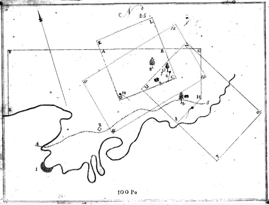
The annexed connected platt No. 25, was returned in this cause, of which the following is an
EXPLANATION
EFGHI, Complainant's survey of 1000 acres. KLCD, the defendant's survey of 235 acres, part of 400 acres entered by Jacob Myers, according to his deed. ABCD, the interference, containing 159 1-2 acres. MNOP, the defendant's survey, laid down by order of the complainant, as he thinks agreeably to entry. 11 12 13 14, Jacob Myer's entry of 400 acres agreeably to the decree of the court. 1, The Long lick. 4 to 5, the old Buffaloe road. 2, the Ash cabbin. 3, the spring, cabbin, and Beech tree marked RS, called for in the complainant's entry. 6, the Sinking spring and Elm. 7, the improvement. 8, a Beech stump in the defendant's meadow, standing 34 poles from his house No. 30 Wt. 9, the defendant's house. 10, a spring running So. 50 Et. from the head. The water course—Long lick creek, or run.
It was agreed by the parties that the distance from Bullitt's lick was about six miles.
The parties agreed to wave the enquiry of facts by a jury, and submitted the question of fact, as well as of law to the court.
Several witnesses were examined to prove the objects called for by the two entries.
Murray & Hughes for the Complainant.
Nicholas & Breckinridge for the Defendant.
It was contended by the counsel for the complainant: That it was not material to enquire whether the complainant's entry was surveyed exactly right or not. For it would be admitted, that, let his entry be laid off in any form including all the objects called for, which are established by the testimony, and running North East for quantity, it would include all the land in dispute.
The entry of the defendant, they contended, was vague and uncertain. it called for a distance from Bullitt's lick, on the South side of Salt River without giving any course.
But admitting the place claimed was the one intended, and was properly described, the survey was improperly made.
The Beech tree marked I.R. could not be considered as sufficiently identified, and the spring running a South East course, was too far from the clearing or improvement, to be considered in ascertaining the mode in which the survey ought to have been in a square form, the lines running to the cardinal points; and the cabbin and cleared land in the centre.
For the defendant it was urged, that the entry of the complainant ought to be taken as it stood before the marginal notes were made.
The law directed, that entries should be made by the surveyor in a book to be kept for that purpose, in which there should be kept no blank leaves, or spaces between the different entries. Chanc. Rev. 95, Sec. 3.
The intention of the legislature was certainly to prevent entries being altered.
And if entries could be amended at all, the amendment ought to be made by another entry in the body of the book, the date of which would appear.
If it might be done by a marginal note, a surveyor, amongst whom the greatest speculators were to be found, might, at a late period, have made a young vague entry special, by a marginal note, without a probability of discovery as to the time of the amendment.
The alterations made in this entry by the marginal notes; it was alledged were two. First, As to the beginning. The entry, before it was altered, called for beginning at the Long lick, on the South side of Long lick run, which was altered to east side. And—Secondly, In the call of course for quantity, which in the entry unaltered stood South East, but was changed to North East.
The entry as unaltered, called for the Long Lick on the South side, to extend up and down the run, to include the Ash cabbin and marked trees, and to run South East for quantity.
It ought to have been surveyed on both sides of the run, to run up and down equal distances, and barely to include the objects, and extending to the South East for quantity.
The manner in which the defendant ought to have been surveyed depended upon the court's opinion as to the proof of the objects.
If the cabbin only was established, that ought to have been the centre of a square, with lines running to the cardinal points.
If the Beech stump was proved to be the stump of the tree on which the letters IR were marked, the centre ought to have been half way between those objects.
And if the spring at 10 was proved, the centre ought to have been taken between the three objects.
It was said for the complainant in reply: That as no fraud was either charged or proved, as to the amendment of the entry by marginal note, and as the amendment was made by a sworn officer, it would not be presumed.
And if the amendment was fairly made, it operated as well as notice, as if made in the body of the book.
At the last term the following interlocutory decree was pronounced:
By the Court—It appearing that the entry on which the claim of the defendant is founded, is of prior date to that of the complainant's entry. The first question will be, Has this entry been made as the law required, and how ought the survey thereon to have been made?
The entry calls for a cabbin and cleared land, and a spring running a South East course, and a Beech tree marked IR.
It seems to the court, that the two first calls have been sufficiently identified, and that they were sufficiently notorious when the entry was made to give it validity. But as two Beech trees marked IR at a considerable distance from each other are proven; it seems to the court, that the last call is too uncertain to be regarded: therefore the court is of opinion, that the survey on this entry should have been made in a right angled form, and as much longer than wide, as the cabbin and spring are distant from each other, and so as to include the spring and cabbin at equal distances from the sides and ends thereof, in which they are respectively placed. On considering a similar question relative to the entry and survey of the complainant—It seems to the court that all the calls of his entry have been sufficiently identified, and that they were sufficiently notorious when his entry was made; and from inspection of the surveys returned, it seems to the court, that the complainant's survey, tho' it is not made altogether agreeable to entry, does not include more of that part of the defendant's survey, which as been made contrary to entry, nor does it include it, otherwise than it would have done, if it had been made in any other manner to comply with the calls of his entry, taken in consistency with each other, and also in a legal form so far as these calls would permit: Therefore the court is of opinion, that the complainant ought to recover from the defendant, all the land included in his survey, which is included in the defendant's survey, and which will not be included therein when the entry on which it was made, is surveyed as above specified: Whereupon it is decreed and ordered, that the complainant do recover of the defendant, all the land which will be included in the survey, when made agreeably to the foregoing opinion, and which is now included within his present survey.
And now at this term, the surveyor's reports having been returned, the defendant was decreed and ordered to convey to the complainant the interference, amounting to twenty and a half acres, and to pay costs.
While we have not yet located the 1780 plats described above, we did located a 1785 survey for Benjamin Frye which is remarkably similar to the one in this case. Here it is as transcribed:
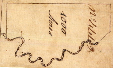
"Surveyed for Benjamin Fry 1000 acres of land in Nelson County by virtue of a Treasury Warrant No. 3972, Lying on Long lick Creek. Including the land where the said Fry now lives. Beginning at two Hickories and and Elm on the north bank of long lick Creek, Running thence N 15 E 200 poles to two pines on the side of a Knob, thence S 75 E 598 poles to an Elm & Sugartree, S 15 W 160 poles to a beech & Sugar Sapling, S 60 W 100 poles to a Walnut and two box Elders on the bank of Long lick Creek thence Down the Several Courses thereof and binding thereto to the Beginning. (signed) Isaac Cox, Will May, (dated) 2 Nov 1785."
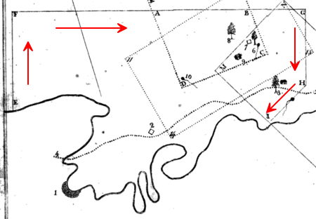
Below are two maps. The one on the left is taken from the case map shown above; the one on the right is from the 1785 Frye survey just described, that we have rotated to conform to the layout of the first map. Judge for yourself.
If you, the reader, have an interest in any particular part of our county history, and wish to contribute to this effort, use the form on our Contact Us page to send us your comments about this, or any Bullitt County History page. We welcome your comments and suggestions. If you feel that we have misspoken at any point, please feel free to point this out to us.
The Bullitt County History Museum, a service of the Bullitt County Genealogical Society, is located in the county courthouse at 300 South Buckman Street (Highway 61) in Shepherdsville, Kentucky. The museum, along with its research room, is open 10 a.m. to 4 p.m. Monday through Friday. Saturday appointments are available by calling 502-921-0161 during our regular weekday hours. Admission is free. The museum, as part of the Bullitt County Genealogical Society, is a 501(c)3 tax exempt organization and is classified as a 509(a)2 public charity. Contributions and bequests are deductible under section 2055, 2106, or 2522 of the Internal Revenue Code. Page last modified: 12 Sep 2024 . Page URL: bullittcountyhistory.org/bchistory/frye_vs_essry.html