
The heirs of John B. Summers requested and received a division of his lands in October 1868. Each of the deeds began with statements similar to the paragraphs below.
This indenture made an entered into this _ day of October 1868 between Wilson Summers, Mary B. Summers, Fanny Summers, Gabriel Summers, Martha J. Talbott formerly Summers, Rachel Irvine formerly Summers, John R. Summers, Noah B. Summers, heirs of John B. Summers, deceased, of the first part by R. J. Meyler, commissioner, and Franklin Summers of the second part.
Witnesseth that whereas a petition in equity was on the sixth day of July 1866, filed in the Bullitt Circuit Court in the name of Gabriel Summers, executor of John B. Summers, deceased, and the heirs of said decedent asking a decree of division of the lands of said decedent, and the court by its decree rendered 21st of August 1866, a division was ordered and commissioners were appointed, and on 17 April 1867 the commissioners S. N. Brooks, W. B. M. Brooks, and Casper Herps, surveyor, returned their report which was confirmed, and R. J. Meyler was appointed a commissioner to convey to the parties on the 24th of April 1868. Now therefore the first parties by the commissioner aforesaid hereby bargain, sell, convey, confirm and deliver unto the second party with covenant of general warranty the following realty as divided by the commissioners, to wit.
Then followed a description of the boundary of the part deeded to that heir, like the one shown below for Franklin Summers.
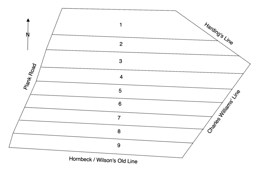
Lot No. 1 we allotted to Franklin Summers containing 54 acres and 30 poles. Beginning at a stake on the east edge of the plank road, corner to G. T. Bailey, thence with Bailey and Strothers' line S 88 3/4° E 171 3/4 poles to a stone in Harding's patent line, thence with the same S 54 1/2° for 55° E 78 3/4 poles to a stake, division corner to Wilson Summers' lot, thence N 88° W 253 poles to a stake on the east edge of the plank road, thence with the same N 21 1/2° E 42 1/2 poles to the beginning.
These nine deeds appear in Bullitt County Deed Book R, on pages 305-315. The boundary descriptions of other deeds are transcribed below this drawing of the plat.
Wilson Summers' Allotment
Lot No. 2 we allotted to Wilson Summers containing 38 3/4 acres and including the house and improvements of John B. Summers dec'd. Beginning at a stake on the east edge of the plank road, division corner to Franklin Summers' lot, thence S 88° E 253 poles to a stake in Harding's patent line, thence with the same S 54 1/2° for 55° E 40 1/2 poles to a stone at a cliff of rocks, division corner to Mary B. Summers, thence with her line N 88° W 297 poles to a stake on the east edge of the plank road, thence with the road N 21 1/2° E 24 3/4 poles to the beginning.
Mary B. Summers' Allotment
Lot No. 3 we allotted to Mary B. Summers. Beginning at a stake on the east edge of the plank road, division corner to Wilson Summers, thence S 88° E 297 poles to a stone near a cliff of rocks in Harding's patent line, thence with the same S 54 1/2° for 55° E 20 1/2 poles to a large beech (the elm gone), said Harding's corner, also patent corner to Charles Williams' 365 acre survey, thence with said Williams' line S 35 3/4° for 35° W 19 1/2 poles to a hickory and white walnut, division corner to Fannie Summers, thence N 88° W 310 poles to a stake on the east edge of the plank road, thence with the same N 21 1/2° E 28 poles to the beginning.
Fannie Summers' Allotment
Lot No. 4 we allotted to Fannie Summers. Beginning at a stake on the east edge of the plank road, division corner to Mary B. Summers, thence with her line S 88° E 310 poles to a hickory and white walnut in Charles Williams' patent line of his 365 acres, thence with said line S 35 3/4° for 35° W 29 poles, crossing Cedar Creek to a stake, division corner to Gabriel Summers, thence with his line N 88° W 296 poles to a stake on the east edge of the plank road, thence with the same N 17° E 25 1/3 poles to the beginning containing 45 3/4 acres.
Gabriel Summers' Allotment
Lot No. 5 we allotted to Gabriel Summers containing 43 1/8 acres. Beginning at a stake on the east edge of the plank road, division corner to Fannie Summers, thence with her line S 88° E 296 poles to a stake in the patent line of Charles Williams' 365 acre survey, thence with the same S 35 3/4° for 35° W 25 3/4 poles to a stake opposite two beeches and black oaks, division corner to Martha J. Talbott, thence with her line N 88° W 290 poles to a stake on the east edge of the plank road, thence with the road N 17° E 23 2/5 poles to the beginning.
Martha J. Talbott's Allotment
Lot No 6 we allotted to Martha J. Talbott containing 37 acres. Beginning at a stake on east edge of the plank road, division corner to Gabriel Summers, thence with his line S 88° E 290 poles to a stake opposite two beeches and black oak in Charles Williams' patent line of his 365 acre survey, thence with the same S 35 3/4° for 35° 26 1/2 poles to a stake, division corner to Rachel Irvine, thence with her line N 88° W 283 poles to a stake on the east edge of the plank road, thence with the same N 23° E 22 poles 23 links to the beginning.
John R. Summers' Allotment
Lot No. 9 we allotted to John R. Summers containing 35 acres, 1 rood, 28 poles. Beginning at a stake on the east edge of the plank road in Hornbeck's or Wilson's old line, thence with the same S 88° E 265 poles to a stone planted in the crook or bend of the road, and is said to stand in the original line of Charles Williams' 365 acre survey, and corner to 33 acres sold by John B. Summers to Mathew Wilson, thence with Williams' old line N 35 3/4° for 35° 28 2/5 poles to a stake, division to Noah B. Summers, thence with his division line N 88° W 271 3/4 poles to a stake on the east edge of the plank road, thence with the road S 17° W 22 1/2 poles to the beginning.
Rachel Irvine's Allotment
Lot No. 7 we allotted to Rachel Irvine containing 36 1/2 acres. Beginning at a stake on the east edge of the plank road, division corner to Martha J. Talbott, thence with her line S 88° E 283 poles to a stake in Charles Williams' patent line of his 365 acres survey, thence with the same S 35 3/4° for 35° 23 1/4 poles to a stake, division corner to Noah B. Summers, thence with his line N 88° W 277 poles to a stake on the east side of the plank road, thence with the road N 23° E 22 poles to the beginning.
Noah B. Summers' Allotment
Lot No. 8 we allotted to Noah B. Summers containing 35 3/4 acres. Beginning at a stake on the east edge of the plank road, division corner to Rachel Irvine, thence with her line S 88° E 277 poles to a stake in Charles Williams' patent line of his 365 acre survey, thence with said line S 35 3/4° for 35° W 25 3/5 poles to a stake, division corner to John R. Summers, thence with his line N 88° W 271 3/4 poles to a stake at the plank road, thence with the same N 23° E 22 1/4 poles to the beginning.
You may view images of the original deeds by following this link.
If you, the reader, have an interest in any particular part of our county history, and wish to contribute to this effort, use the form on our Contact Us page to send us your comments about this, or any Bullitt County History page. We welcome your comments and suggestions. If you feel that we have misspoken at any point, please feel free to point this out to us.
The Bullitt County History Museum, a service of the Bullitt County Genealogical Society, is located in the county courthouse at 300 South Buckman Street (Highway 61) in Shepherdsville, Kentucky. The museum, along with its research room, is open 10 a.m. to 4 p.m. Monday through Friday. Saturday appointments are available by calling 502-921-0161 during our regular weekday hours. Admission is free. The museum, as part of the Bullitt County Genealogical Society, is a 501(c)3 tax exempt organization and is classified as a 509(a)2 public charity. Contributions and bequests are deductible under section 2055, 2106, or 2522 of the Internal Revenue Code. Page last modified: 12 Sep 2024 . Page URL: bullittcountyhistory.org/bchistory/jbsummers-landdivision.html