
On 22 Aug 1863, the siblings of Lewis W. Samuels sold family land to Minerva Samuels, Lewis' widow, including land that had been deeded to him by his father. The deed is transcribed below.
Bullitt County Deed Book P, Page 277-278
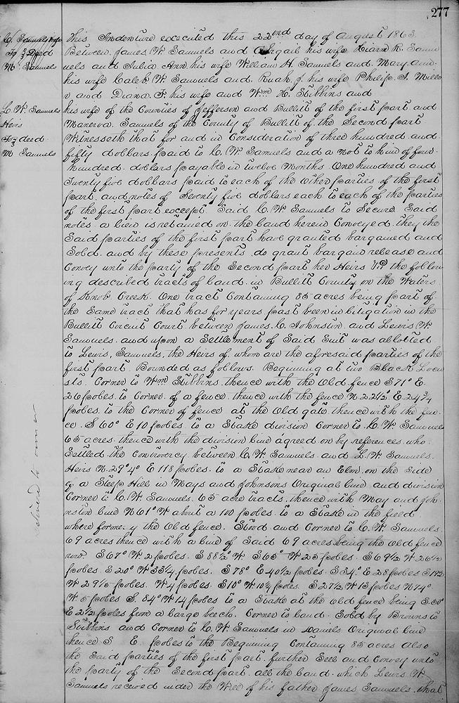
This indenture executed this 22nd day of August 1863 between James W. Samuels and Abigail his wife, Hiram R. Samuels and Jubia Ann his wife, William H. Samuels and Mary Ann his wife, Caleb W. Samuels and Ruah J. his wife, Philip J. Miller and Diana F. his wife and William H. Stibbins and [Theresa] his wife of the counties of Jefferson and Bullitt of the first part, and Minerva Samuels of the county of Bullitt of the second part.
Witnesseth that for and in consideration of $350 paid to C. W. Samuels and a note to him of $400 payable in 12 months, $125 paid to each of the other parties of the first part, and notes of $75 each to each of the parties of the first part, except said C. W. Samuels. To secure said notes a lien is retained on the land herein conveyed. They the said parties of the first part have granted, bargained and sold and by these presents do grant, bargain, release and convey unto the party of the second part, her heirs &c, the following described tracts of land in Bullitt County on the waters of Knob Creek; one tract containing 85 acres being part of the same tract that has for years past been in litigation in the Bullitt Circuit Court between James C. Johnston and Lewis W. Samuels, and upon a settlement of said suit was allotted to Lewis Samuels, the heirs of whom are the aforesaid parties of the first part, bounded as follows.
Beginning at two black locusts, corner to William Stibbins, thence with the old fence S 71° E 26 poles to corner of a fence, thence with the fence N 22 1/2° E 24 3/4 poles to corner of the fence at the gate, thence with the fence S 60° E 10 poles to a stake, division corner to C. W. Samuels' 65 acres, thence with the division line agreed on by referees who settled the controversy between C. W. Samuels and L. W. Samuels' heirs N 29°4' E 118 poles is a stake near an elm on the side of a steep hill in Mays and Johnson's original line and division corner to C. W. Samuels' 65 acre tracts, thence with May and Johnston's line N 61° W about a 100 poles to a stake in the field where formerly the old fence stood, and corner to C. W. Samuels' 69 acres, thence with a line of said 69 acres being the old fence row S 67° W 2 poles, S 88 1/2° W [...], S 65° W 25 poles, S 69 1/2° W 26 1/2 poles, S 20° W 33 1/4 poles, S 78° E 40 1/2 poles, S 34° E 28 poles, S 19 1/2° W 29 1/5 poles, West 4 poles, S 10° W 10 1/4 poles, S 27 1/2 W 13 poles, N 74° W 5 poles, S 84° W 14 poles to a stake at the old fence being, S 50° E 2 1/2 poles from a large beech, corner to land sold by Browns to Stubbins, and corner to C. W. Samuels in Daniels' original line, thence S __ E __ to the beginning containing 85 acres.
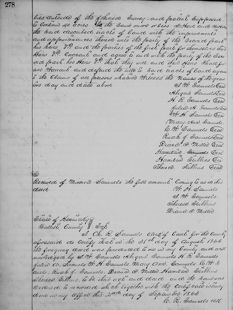
Also the said parties of the first part further sell and convey unto the party of the second part all the land which Lewis W. Samuels received under the will of his father, James Samuels that lies outside of the Johnson survey and patent, supposed to contain 40 acres, be the same more or less. To have and to hold the said described tracts of land with the improvements and appurtenances thereon unto the party of the second part, his heirs &c and the parties of the first part for themselves, their heirs &c covenant and agree to and with the party of the second part, her heirs &c that they will and their heirs shall forever warrant and defend the title to said tracts of land against the claims of all persons whatever. Witness the names of the grantors day and date above.
(signed) J. W. Samuels, Abigail Samuels, H. R. Samuels, Julia A. Samuels, W. H. Samuels, Mary Ann Samuels, C. W. Samuels, Ruah J. Samuels, Diana F. Miller, Hamilton Stibbins, Therece Stibbins.
If you, the reader, have an interest in any particular part of our county history, and wish to contribute to this effort, use the form on our Contact Us page to send us your comments about this, or any Bullitt County History page. We welcome your comments and suggestions. If you feel that we have misspoken at any point, please feel free to point this out to us.
The Bullitt County History Museum, a service of the Bullitt County Genealogical Society, is located in the county courthouse at 300 South Buckman Street (Highway 61) in Shepherdsville, Kentucky. The museum, along with its research room, is open 10 a.m. to 4 p.m. Monday through Friday. Saturday appointments are available by calling 502-921-0161 during our regular weekday hours. Admission is free. The museum, as part of the Bullitt County Genealogical Society, is a 501(c)3 tax exempt organization and is classified as a 509(a)2 public charity. Contributions and bequests are deductible under section 2055, 2106, or 2522 of the Internal Revenue Code. Page last modified: 12 Sep 2024 . Page URL: bullittcountyhistory.org/bchistory/lewissiblings-minerva-2tracts.html