
Links to Wilson's will and the division of his Estate - Part 2 | Part 3
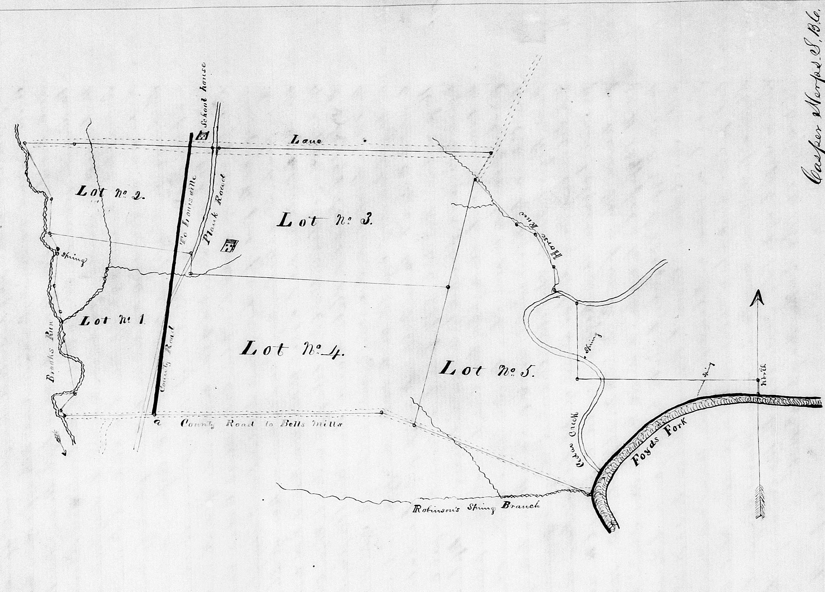
By the time of his death, Matthew Wilson had accumulated a significant amount of land in north-central Bullitt County, mostly located north of Bell's Mill Road, west of Floyd's Fork, and east of Brooks' Run as shown in the plat drawing including further down this page.
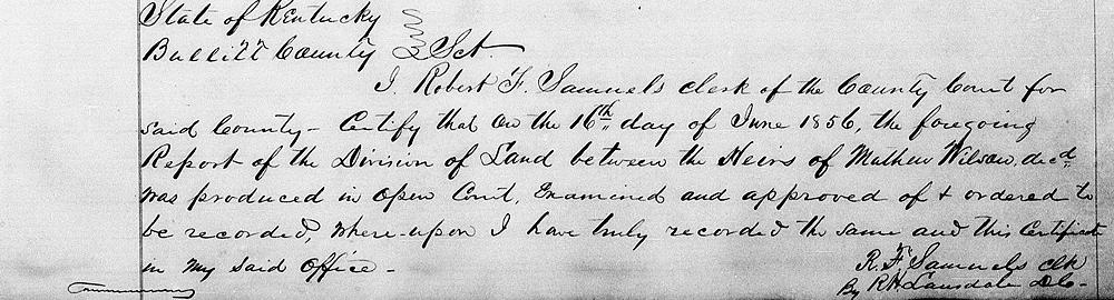
In May 1856, his heirs filed a petition with the County Court to have Solomon N. Brooks, Rufus K. Summers and John Holsclaw appointed as commissioners to divide this land amongst the heirs according to the dictates of his will. These same men were also appointed to appraise the value of Wilson's slaves and his personal estate.
Casper Herps, the County Surveyor, was assigned to assist in this land division. His first report, as recorded in Bullitt County Will Book F, pages 3-5, is transcribed below. It describes his home farm.
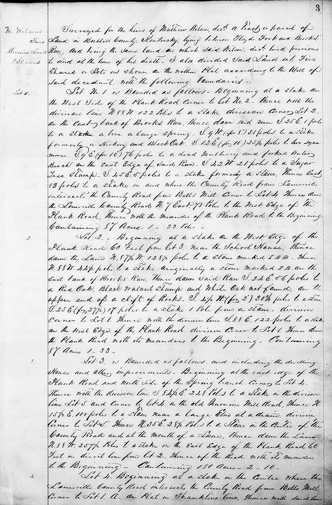
Surveyed for the heirs of Mathew Wilson, dec'd, a tract or parcel of land in Bullitt County, Kentucky, lying between Floyd's Fork and Brooks' Run, and being the same land on which said Wilson, dec'd, lived previous to and at the time of his death. I also divided said land into five shares or lots as shown on the within plat according to the will of said decedent, with the following boundaries.
Lot No. 1 is bounded as follows. Beginning at a stake on the west side of the Plank Road, corner to Lot No. 2, thence with the division line N 88° W 122 poles to a stake, division corner Lot 2, on the east bank of Brooks' Run, thence down said run S 25° E 1 pole to a stake above a large spring, S 9° W (for 8°) 31 poles to a stake, formerly a hickory and black oak, S 12° E (for 10°) 25¼ poles to two sycamores, S 9° E (for 10°) 76 poles to a dead mulberry and forked water beech on the east edge of said run, S 42° W 21 poles to a sugar tree stump, S 45° E 5 poles to a stake, formerly a stone, thence East 83 poles to a stake in and where the county road from Louisville intersects the county road from Bell's Mill, corner to Lot 4, thence down the Louisville County Road N 7° East 78 poles to the west edge of the Plank Road, thence with the meander of the Plank Road to the beginning, containing 87 acres - 1 - 33 poles.
Lot 2 - Beginning at a stake on the West edge of the Plank Road, 60 feet from lot 3 near the School House, thence down the lane N 87¼° W 128½ poles to a stone marked I. A. B., thence N 88° W 44½ poles to a stake, originally a stone, marked I. A. on the east bank of Brooks' Run, thence down said run S 24° E 56 poles to a red oak, black oak stump and white oak, not found, on the upper end of a clift of rocks, S 4½° W (for 2°) 30¾ poles to a stone, S 25° E (for 27½°) 17 poles to a stake, 1 pole from a stone, division corner to Lot 1, thence with the division line S 88° E 122 poles to a stake on the west edge of the Plank Road, division corner to Lot 1, thence down the Plank Road with its meanders to the beginning, containing 87 acres 1-33.
Lot 3 is bounded as follows and including the dwelling house and other improvements. Beginning at the east edge of the Plank Road and north side of the spring branch, corner to Lot 4, thence with the division line S 84½ E 248 poles to a stake in the division line Lot 5, and corner to Lot 4 in the old Yenowine Mill Road, thence N 15½° E 100 poles to a stone near a large elm at a drain, division corner to Lot 5, thence N 35° E 28½ poles to a stone in the center of the County Road and at the mouth of a lane, thence down the Lane N 88° W 257½ poles to a stake on the east edge of the Plank Road, 60 feet in direct line from Lot 2, thence up the Road with its meanders to the beginning, containing 180 acres - 2 - 10.
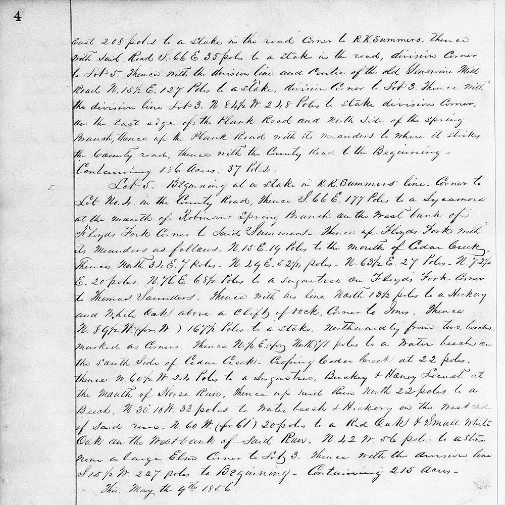
Lot 4, Beginning at a stake in the center where the Louisville County Road intersects the County Road from Bell's Mill, corner to Lot 1, A on plat in Shanklin's line, thence with said line East 208 poles to a stake in the road, corner to R. K. Summers, thence with said road S 66° E 35 poles to a stake in the road, division corner to Lot 5, thence with the division line and center of the old Yenowine Mill Road, N 15½° E 127 poles to a stake, division corner to Lot 3, thence with the division line Lot 3, N 84½° W 248 poles to stake, division corner on the east edge of the Plank Road and north side of the spring branch, thence up the Plank Road with its meanders to where it strikes the County Road, thence with the County Road to the beginning, containing 186 acres, 37 poles.
Lot 5 Beginning at a stake in R. K. Summers' line, corner to Lot No. 4 in the County Road, thence S 66° E 177 poles to a sycamore at the mouth of Robinson's Spring Branch on the west bank of Floyd's Fork, corner to said Summers, thence up Floyd's Fork with its meanders as follows: N 15° E 19 poles to the mouth of Cedar Creek, thence North 34° E 7 poles, N 49° E 52¼ poles, N 63½° E 27 poles, N 72½° E 20 poles, N 76° E 68½ poles to a sugar tree on Floyd's Fork, corner to Thomas Saunders, thence with his line North 13½ poles to a hickory and white oak above a clift of rock, corner to Jones, thence N 89½° W (for West) 167½ poles to a stake northwardly from two beeches marked as corners, thence N¼° E (for North) 71 poles to a water beech on the south side of Cedar Creek, crossing Cedar Creek at 22 poles, thence N 60½° W 24 poles to a sugar tree, buckeye and honey locust at the mouth of Horse run, thence up said run North 22 poles to a beech, N 30°10' W 33 poles to water beech and hickory on the west side of said run, N 60° W (for 61°) 20 poles to a red oak and small white oak on the west bank of said run, N 42° W 56 poles to a stone near a large elm, corner to Lot 3, thence with the division line S 15½° W 227 poles to beginning, containing 215 acres.
This May the 9th 1856.
If you, the reader, have an interest in any particular part of our county history, and wish to contribute to this effort, use the form on our Contact Us page to send us your comments about this, or any Bullitt County History page. We welcome your comments and suggestions. If you feel that we have misspoken at any point, please feel free to point this out to us.
The Bullitt County History Museum, a service of the Bullitt County Genealogical Society, is located in the county courthouse at 300 South Buckman Street (Highway 61) in Shepherdsville, Kentucky. The museum, along with its research room, is open 10 a.m. to 4 p.m. Monday through Friday. Saturday appointments are available by calling 502-921-0161 during our regular weekday hours. Admission is free. The museum, as part of the Bullitt County Genealogical Society, is a 501(c)3 tax exempt organization and is classified as a 509(a)2 public charity. Contributions and bequests are deductible under section 2055, 2106, or 2522 of the Internal Revenue Code. Page last modified: 12 Sep 2024 . Page URL: bullittcountyhistory.org/bchistory/matthew-wilson-land-division.html