
On 18 Aug 1868, Augustin and Sarah (Wilson) Moreman sold 212 acres of land on the north side of Salt River on Floyd's Fork and Cedar Creek to Chaddie Johnson, wife of Jilson P. Johnson. This tract included 169 acres willed to here by her father, Matthew Wilson, and 43 acres she inherited from her brother John Fry Wilson.
Bullitt County Deed Book R, pages 195-197
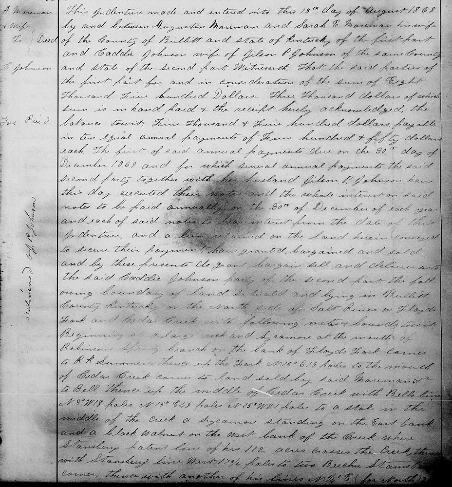
This indenture made and entered into this 18th day of August 1868 by and between Augustin Moreman and Sarah E. Moreman his wife of the county of Bullitt and state of Kentucky of the first part and Caddie Johnson, wife of Jilson P. Johnson, of the same county and state of the second part. Witnesseth that the said parties of the first part for and in consideration of the sum of $8500, $3000 of which sum is in hand paid and the receipt hereby acknowledged, the balance, to wit, $5500 payable in 10 equal annual payments of $550 each. The first of said annual payments due on the 30th day of December 1869, and for which several annual payments the said second party together with her husband, Jilson P. Johnson have this day executed their notes, and the whole interest on said notes to be paid annually on 30th of December of each year and each of said notes to bear interest from the date of this indenture, and a lien retained on the land herein conveyed to secure their payment, have granted, bargained and sold and by these presents do grant, bargain, sell and deliver unto the said Caddie Johnson, party of the second part the following boundary of land situated and lying in Bullitt County, Kentucky on the north side of Salt River on Floyd's Fork and Cedar Creek with the following metes and bounds, to wit.
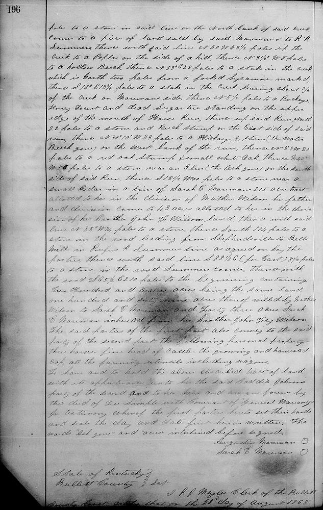
Beginning at a large rock and sycamore at the mouth of Robinson Spring branch on the bank of Floyd's Fork, corner to R. K. Summers, thence up the Fork N 15° E 19 poles to the mouth of Cedar Creek, corner to land sold by said Moreman &c to Bell, thence up the middle of Cedar Creek with Bell's line N 3° W 18 poles, N 15° E 48 poles, N 15° W 21 poles to a stake in the middle of the creek, a sycamore standing on the east bank, and a black walnut on the west bank of the creek where Stansbury's patent line of his 112 acres crosses the creek, thence with Stansbury's line West 17 3/4 poles to two beeches, Stansbury's corner, thence with another of his lines N 1/4° E (for North) 24 3/4 poles to a stone in said line on the north bank of said creek, corner to a piece of land sold by said Moreman &c to R. K. Summers, thence with said line N 60° W 63 1/2 poles up the creek to a poplar on the side of a hill, thence N 3 1/2° W 8 poles to a hollow beech, thence N 53° E 28 poles to a stake in the creek which is north two poles from a forked sycamore marked, thence S 76° E 18 3/4 poles to a stake in the creek, leaving about 2/3 of the creek on Moreman side, thence North 5 1/2 poles to a buckeye, honey locust and dead sugar tree standing on the upper edge of the mouth of Horse Run, thence up said Run North 22 poles to a stone and beech stump on the east side of said Run, thence N 30°10' W 33 poles to a hickory and stone, (the water beech gone) on the west bank of the Run, thence N 59° W 20 poles to a red oak stump and small white oak, thence N 42° W 56 poles to a stone near to an elm (the ash gone) on the south side of said Run, thence S 15 1/2° W 100 poles to a stone near a small cedar in a line of Sarah E. Moreman's 215 acre tract allotted to her in the division of Matthew Wilson, her father, and division corner to 43 acres allotted to her in the division of her brother John F. Wilson's land, thence with said line N 85° W 74 poles to a stone, thence South 114 poles to a stone in the road leading from Shepherdsville to Bell's mill in Rufus K. Summer's line as agreed on by the parties, thence with said line S 88 1/2° E (for East) 8 1/3 poles to a stone in the road, Summer's corner, thence with the road S 65 1/2° E 210 poles to the beginning, containing 212 acres, being the same land, 169 acres thereof willed by Matthew Wilson to Sarah E. Moreman and 43 acres Sarah E. Moreman inherited from her brother John Fry Wilson.
The said parties of the first part also convey to the said party of the second part the following personal property, three horses, five head of cattle, the growning and harvested crops, all the farming utensils including wagons.
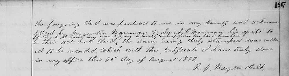
To have and to hold the above described tract of land with its appurtenances unto her the said Caddie Johnson, party of the second part, and to her heirs and assigns forever by this deed of fee simple with covenant of general warranty. For testimony whereof the first parties hereto set their hands and seals the day and date first herein written. The words "ash gone" and "acres" interlined before signed. (signed) Augustin Moreman, Sarah E. Moreman.
If you, the reader, have an interest in any particular part of our county history, and wish to contribute to this effort, use the form on our Contact Us page to send us your comments about this, or any Bullitt County History page. We welcome your comments and suggestions. If you feel that we have misspoken at any point, please feel free to point this out to us.
The Bullitt County History Museum, a service of the Bullitt County Genealogical Society, is located in the county courthouse at 300 South Buckman Street (Highway 61) in Shepherdsville, Kentucky. The museum, along with its research room, is open 10 a.m. to 4 p.m. Monday through Friday. Saturday appointments are available by calling 502-921-0161 during our regular weekday hours. Admission is free. The museum, as part of the Bullitt County Genealogical Society, is a 501(c)3 tax exempt organization and is classified as a 509(a)2 public charity. Contributions and bequests are deductible under section 2055, 2106, or 2522 of the Internal Revenue Code. Page last modified: 12 Sep 2024 . Page URL: bullittcountyhistory.org/bchistory/moreman-johnson.html