
On 4 Dec 1838, the heirs of Joseph Nichols sold this land to Samuel Nichols. This land ran from the mouth of Cedar Point Branch upstream toward Pitts Point, and was part of the 2000 acres patented to Samuel Beall. It is shown on this part of a plat found in the T. C. Carroll Plats.
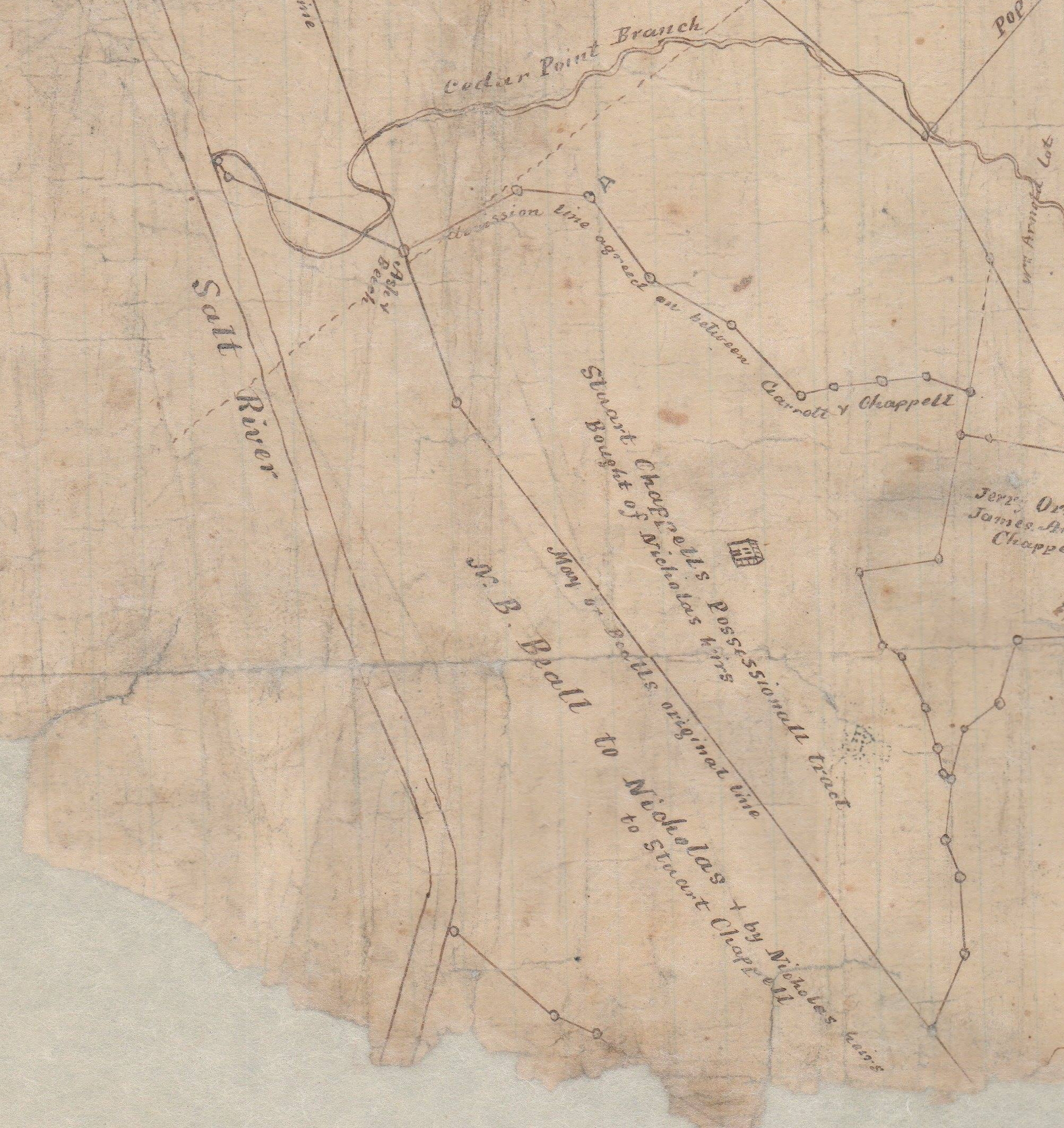
On 4 Mar 1857, some of the legatees of Samuel Nichols sold their three-quarters of this land to Stuart Chappell. They included Shadrack A. Nichols and his wife Ellen, and Clementine Nichols Turrentine and her husband John, all of Monroe County, Arkansas, and Lemuel and John W. Nichols of Bullitt County. Then on 28 Feb 1865, Delia Nichols Jeffries deeded her part of the title to this land to Chappell as well. Of these, Shadrack Nichols and Delia Jeffries were children of Joseph Nichols, while Clementine Turrentine, Lemuel Nichols and John W. Nichols were children of Samuel Nichols.
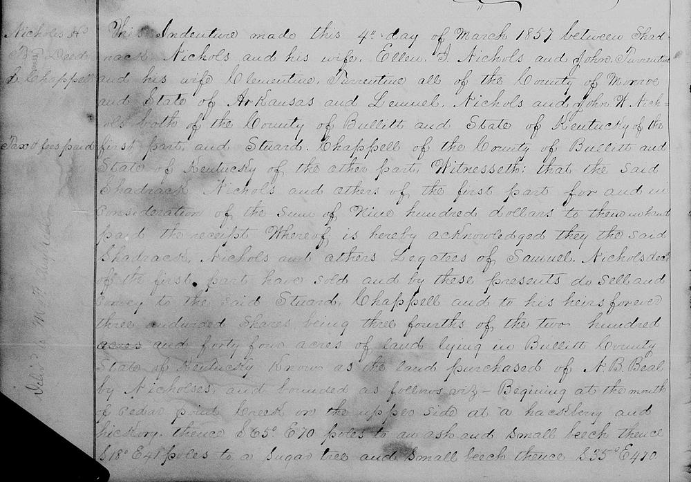
Bullitt County Deed Book P, Page 222-223
This indenture made this 4th day of March 1857 between Shadrack Nichols and his wife Ellen J. Nichols, and John Turrentine and his wife Clementine Turrentine, all of the County of Monroe and State of Arkansas, and Lemuel Nichols and John W. Nichols, both of the County of Bullitt and State of Kentucky of the first part, and Stuard Chappell of the County of Bullitt and State of Kentucky of the other part. Witnesseth that the said Shadrack Nichols and others of the first part for and in consideration of the sum of $900 to them in hand paid, the receipt whereof is hereby acknowledged, they the said Shadrack Nichols and others, legatees of Samuel Nichols dec'd of the first part have sold and by these presents do sell and convey to the said Stuard Chappell and to his heirs forever three undivided shares, being three-fourths of the two hundred acres and forty-four acres of land lying in Bullitt County, State of Kentucky, known as the land purchased of N. B. Beal by Nicholes and bounded as follows, viz.
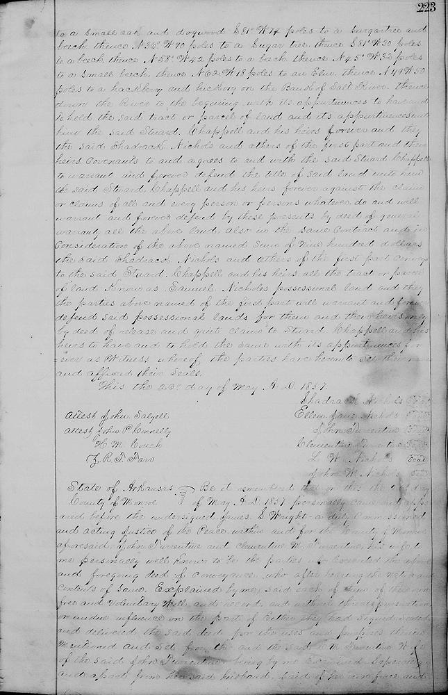
Beginning at the mouth of Cedar Point Creek on the upper side at a hackberry and hickory, thence S 65° E 70 poles to an ash and small beech, thence S 18° E 41 poles to a sugar tree and small beech, thence S 35° E 470 [poles] to a small oak and dogwood, S 81° W 74 poles to a sugar tree and beech, thence N 36° W 90 poles to a sugar tree, thence S 81° W 30 poles to a beech, thence N 58° W 42 poles to a beech, thence N 45° W 32 poles to a small beech, thence N 62° W 18 poles to an elm, thence N 49° W 50 poles to a hackberry and hickory on the bank of Salt River, thence down the river to the beginning with its appurtenances to have and to hold the said tract or parcel of land and its appurtenances unto him the said Stuard Chappell and his heirs forever.
And they the said Shadrack Nichols and others of the first part and their heirs covenants to and agrees to and with the said Stuard Chappell to warrant and forever defend the title of said land unto him the said Stuard Chappell and his heirs forever against the claim or claims of all and every person or persons whatever do and will warrant and forever defend by these presents by deed of general warranty all the above land.
Also in the same contract and in consideration of the above named sum of $900 the said Shadrack Nichols and others of the first part convey to the said Stuard Chappell and his heirs all the tract or parcel of land known as Samuel Nichol's possessional land and they the parties above named of the first part will warrant and forever defend said possessional lands for them and their heirs only by deed of release and quit claim to Stuard Chappell and his heirs to have and to hold the same with its appurtenances forever as witness whereof the parties have hereunto set their names and affixed their seals, this the 26th day of May, A.D. 1857.
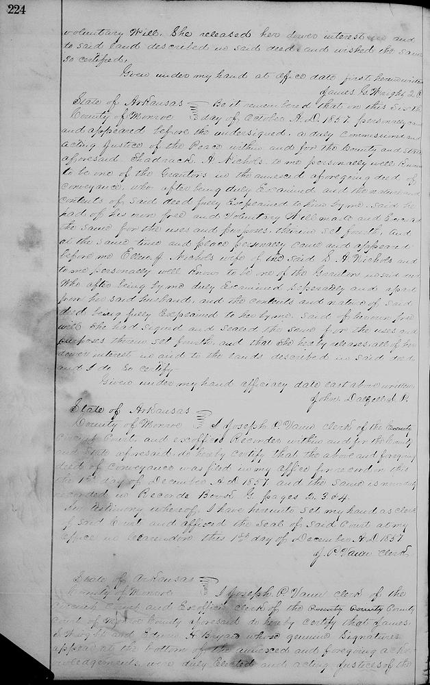
[Indenture was signed by grantors, witnessed, and verified in both Arkansas and Bullitt County.]
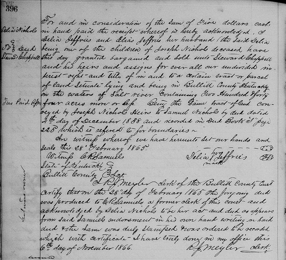
Bullitt County Deed Book Q, Page 396
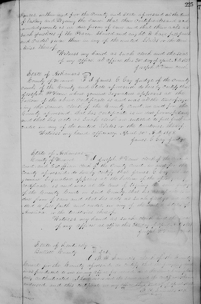
For and in consideration of the sum of five dollars cash in hand paid, the receipt whereof is hereby acknowledged, I Delia Jeffries and Elias Jeffries her husband (the said Delia being one of the children of Joseph Nichols deceased) have this day granted, bargained and sold unto Steward Chappell and his heirs and assigns forever all our undivided interest, right and title of in and to a certain tract or parcel of land situate lying and being in Bullitt County, Kentucky on the waters of Salt River containing 244 acres more or less, being the same tract of land conveyed by Joseph Nichols' heirs to Samuel Nichols by deed dated 4th day of December 1838 and recorded in Deed Book I, page 225 which is referred to for boundaries. In witness whereof we have hereunto set our hands and seals this 28th February 1865. Delia (her x mark) Jeffries.
[Witnessed by C. R. Samuels and recorded in the Bullitt Clerk's office on 6 Nov 1866.]
If you, the reader, have an interest in any particular part of our county history, and wish to contribute to this effort, use the form on our Contact Us page to send us your comments about this, or any Bullitt County History page. We welcome your comments and suggestions. If you feel that we have misspoken at any point, please feel free to point this out to us.
The Bullitt County History Museum, a service of the Bullitt County Genealogical Society, is located in the county courthouse at 300 South Buckman Street (Highway 61) in Shepherdsville, Kentucky. The museum, along with its research room, is open 10 a.m. to 4 p.m. Monday through Friday. Saturday appointments are available by calling 502-921-0161 during our regular weekday hours. Admission is free. The museum, as part of the Bullitt County Genealogical Society, is a 501(c)3 tax exempt organization and is classified as a 509(a)2 public charity. Contributions and bequests are deductible under section 2055, 2106, or 2522 of the Internal Revenue Code. Page last modified: 12 Sep 2024 . Page URL: bullittcountyhistory.org/bchistory/nichols-chappell.html