
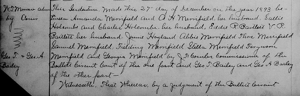
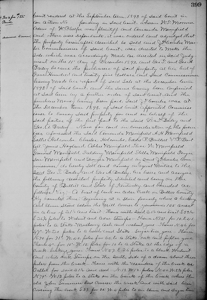
On 27 Dec 1893, the heirs of Nancy F. Phelps, through J. F. Combs, a commissioner appointed by Bullitt Circuit Court, sold at auction an 80 acre tract along Cedar Creek, a tributary of Floyd's Fork, to George T. Bailey and his son, George A. Bailey for $425. This tract was the former site of Jacob Yenawine's mill. We've transcribed the tract description below, and included images of the complete deed.
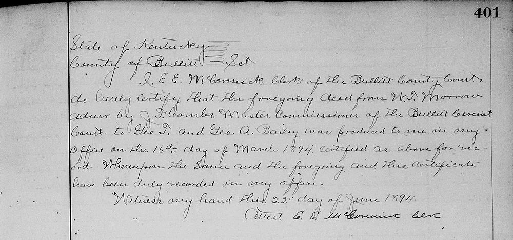
Bullitt County Deed Book 30, Pages 398-401
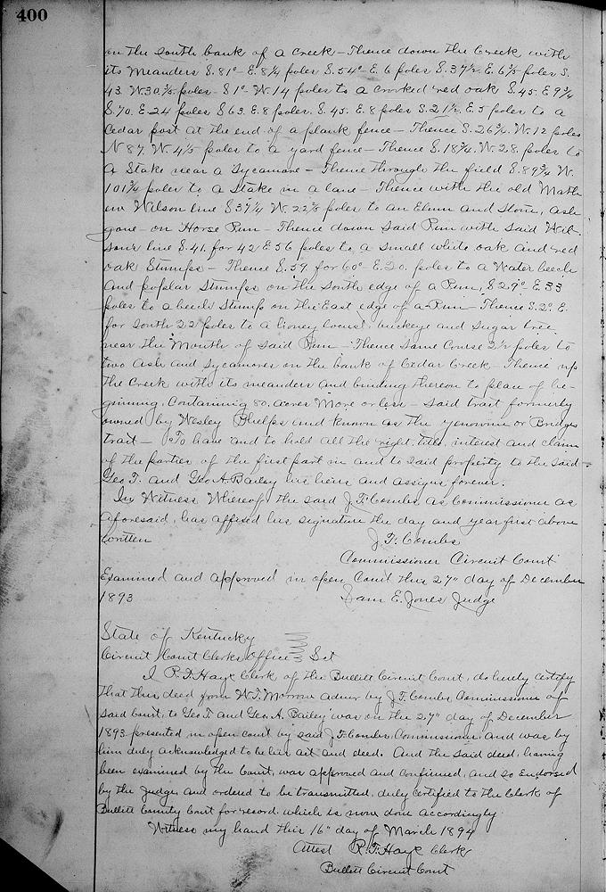
... A tract of land on Cedar Creek in Bullitt County, Ky., bounded thus: Beginning at a stone, formerly where a hickory and elm stood below the mill, corner to Yenawine's 105 acres in a line of 21 1/2 acre tract, thence with said 21 1/2 acre tract S 53 1/2° E 26 3/4 poles to a walnut and cedar stumps, thence N 12° for 10° E 41 poles to a stake, mulberry, ash and walnut gone, thence N 46° for 47° W 20 poles to a beech and stake, sugar tree gone, thence N 70° for 71° W 40 poles for 60 to a stake, pak and poplar gone, thence 4° for 10° W 15 poles for 10 to a stake at the edge of a creek, buckeye gone, thence N 57° E 26 poles to a black walnut and white oak stumps on the south side of a drain about three poles from the creek, thence with the meanders of the creek as called for said 21 1/2 acre deed, N 13° W 12 poles, N 40° W 8 2/3 poles, N 79° W 13 poles to a stake on the bank of the creek where the old John Summers' line crosses the creek and with said line crossing the creek S 37° W 4 poles to an elm and sugar tree on the south bank of a creek, thence down the creek with its meanders S 81° E 8 1/4 poles, S 54° E 6 poles, S 37 1/2° E 6 3/5 poles, S 43° W 30 3/5 poles, S 1° W 14 poles to a crooked red oak, S 45° E 9 3/4 poles, S 70° E 24 poles, S 63° E 8 poles, S 45° E 8 poles, S 21 1/2° E 5 poles to a cedar post at the end of a plank fence, thence S 26 3/4° W 12 poles, N 87° W 4 1/5 poles to a yard fence, thence S 18 3/4° W 28 poles to a stake near a sycamore, thence through the field S 89 3/4° W 101 3/4 poles to a stake in a land, thence with the old Mathew Wilson line S 37 1/2° W 22 2/5 poles to an elm and stone, ash gone, on Horse run, thence down said run with said Wilson's line S 41° for 42° E 56 poles to a small white oak and red oak stumps, thence S 59° for 60° E 30 poles to a water beech and poplar stumps on the south edge of a run, S 29° E 33 poles to a beech stump on the east edge of a run, thence S 2° E for South 22 poles to a honey locust, buckeye and sugar tree near the mouth of said run, thence same course 2 1/2 poles to two ash and sycamore on the bank of Cedar Creek, thence up the creek with its meanders and binding thereon to place of beginning, containing 80 acres, more or less, said tract formerly owned by Wesley Phelps and known as the Yenawine or Bridges tract. ...
If you, the reader, have an interest in any particular part of our county history, and wish to contribute to this effort, use the form on our Contact Us page to send us your comments about this, or any Bullitt County History page. We welcome your comments and suggestions. If you feel that we have misspoken at any point, please feel free to point this out to us.
The Bullitt County History Museum, a service of the Bullitt County Genealogical Society, is located in the county courthouse at 300 South Buckman Street (Highway 61) in Shepherdsville, Kentucky. The museum, along with its research room, is open 10 a.m. to 4 p.m. Monday through Friday. Saturday appointments are available by calling 502-921-0161 during our regular weekday hours. Admission is free. The museum, as part of the Bullitt County Genealogical Society, is a 501(c)3 tax exempt organization and is classified as a 509(a)2 public charity. Contributions and bequests are deductible under section 2055, 2106, or 2522 of the Internal Revenue Code. Page last modified: 12 Sep 2024 . Page URL: bullittcountyhistory.org/bchistory/phelps-bailey-80.html