
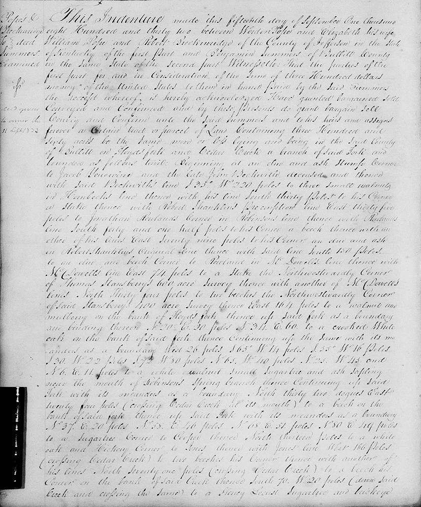
On 15 Sep 1832, Worden Pope, William Pope and Robert Breckinridge sold to Benjamin Summers their rights to 360 acres of land claimed as part of the 21,000 acres claimed by John Larue's heirs and located on the waters of Floyd's Fork and Cedar Creek. The deed is shown below.
Bullitt County Deed Book G, Page 414-415
This indenture made this 15th day of September 1832, between Worden Pope and Elizabeth his wife, William Pope and Robert Breckinridge of the County of Jefferson in the state of Kentucky of the first part and Benjamin Summers of Bullitt County in the same state of the second part. Witnesseth that the parties of the first part for and in consideration of the sum of $300 money of the United States to them in hand paid by the said Summers, the receipt whereof is hereby acknowledged, have granted, bargained, sold, conveyed and confirmed and by these presents do grant, bargain, sell, convey and confirm unto the said Summers and to his heirs and assigns forever a certain tract or parcel of land containing 360 acres, be the same more or less, lying and being in the said County of Bullitt on Floyd's Fork and Cedar Creek, a branch of said fork, and bounded as follows, to wit.
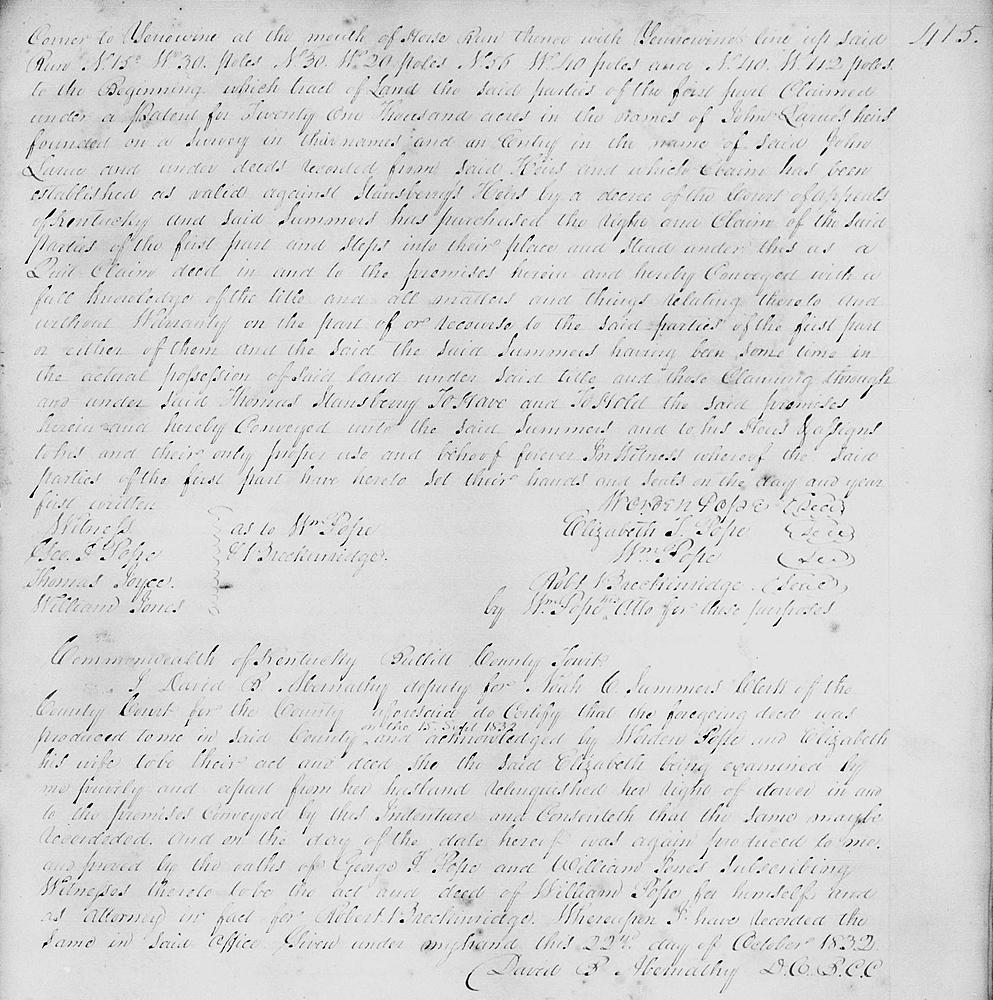
Beginning at an elm and ash stump, corner to Jacob Yenawine and the late John Beckwith dec'd, and thence with said Beckwith's line S 35° W 220 poles to three small walnuts in Hornbeck's line, thence with his line South 30 poles to his corner, a stake, thence with Robert Shanklin's preemption line East 35 poles to Jonathan Rowland's corner in Robinson's line, thence with Rowland's line South 40 1/2 poles to his corner, a beech, thence with another of his lines East 79 poles to his corner, an elm and ash in Robert Shanklin's original line, thence with said line South 150 poles to an elm and beech, corner to Rowland in McDowell's line, thence with McDowell's line East 74 poles to a stake, the northwestwardly corner of Thomas Stansbury's 600 acre survey, thence with another of McDowell's lines North 34 poles to two beeches, the northwestwardly corner of said Stansbury's 400 acre survey, thence East 164 poles to a walnut and mulberry on the bank of Floyd's Fork, thence up said fork as a boundary and binding thereon N 20° E 20 poles, N 34° E 60 [poles] to a crooked white oak on the bank of said fork, thence continuing up the same with its meanders as a boundary West 26 poles, S 65° W 14 poles, S 55° W 16 poles, S 30° W 22 poles, S 72° W 80 poles, N 65° W 40 poles, N 25° W 45 [poles] and N 6° E 11 poles to a white walnut, small sugar tree and ash sapling near the mouth of Robinson's Spring Branch, thence continuing up said Fork with its meanders as a boundary North 32° East 24 poles (crossing Cedar Creek at its mouth) to a beech on the bank of said fork, thence up said Fork with its meanders as a boundary N 37° E 20 poles, N 58° E 46 poles, N 68° E 51 poles, N 80° E 49 poles to a sugar tree, corner to Cooper, thence North 13 poles to a white oak and hickory, corner to Jones, thence with Jones' line West 166 poles (crossing Cedar Creek) to two beeches, his corner, thence with another of his lines North 71 poles (crossing Cedar Creek) to a beech, his corner, on the bank of said Creek, thence South 70° W 20 poles (down said Creek and crossing same) to a honey locust, sugar tree and buckeye corner to Yenawine at the mouth of Horse Run, thence with Yenawine's line up said run N 15° W 30 poles, N 30° W 20 poles, N 56° W 40 poles and N 40° W 112 poles to the beginning.
Which tract of land the said parties of the first part claimed under a patent for 21,000 acres in the name of John Larue's heirs founded on a survey in their names and an entry in the name of said John Larue and under deeds recorded from said heirs and which claim has been established as valid against Stansbury's heirs by a decree of the Court of Appeals of Kentucky, and said Summers has purchased the right and claim of the said parties of the first part and steps into their place and stead under this as a quit claim deed in and to the premises herein and hereby conveyed with a full knowledge of the title and all matters and things relating thereto, and without warranty on the part of or recourse to the said parties of the first part or either of them and the said Summers having been sometime in the actual possession of said land under said title and those claiming through and under said Thomas Stansbury.
To have and to hold the said premises herein and hereby conveyed unto the said Summers and to his heirs and assigns to his and their only proper use and behoof forever. In witness whereof the said parties of the first part have hereto set their hands and seals on the day and year first written.
[Document was signed by the first party and witnessed by George F. Pope, Thomas Joyce and William Jones.]
If you, the reader, have an interest in any particular part of our county history, and wish to contribute to this effort, use the form on our Contact Us page to send us your comments about this, or any Bullitt County History page. We welcome your comments and suggestions. If you feel that we have misspoken at any point, please feel free to point this out to us.
The Bullitt County History Museum, a service of the Bullitt County Genealogical Society, is located in the county courthouse at 300 South Buckman Street (Highway 61) in Shepherdsville, Kentucky. The museum, along with its research room, is open 10 a.m. to 4 p.m. Monday through Friday. Saturday appointments are available by calling 502-921-0161 during our regular weekday hours. Admission is free. The museum, as part of the Bullitt County Genealogical Society, is a 501(c)3 tax exempt organization and is classified as a 509(a)2 public charity. Contributions and bequests are deductible under section 2055, 2106, or 2522 of the Internal Revenue Code. Page last modified: 12 Sep 2024 . Page URL: bullittcountyhistory.org/bchistory/ppb-summers.html