
In April 1860 Charles R. and Mollie E. Samuels sold a portion of 100 acres of land that Samuels had patented in 1857 as vacant land lying near Cane Run and Wilson Creek to Casper Herps. This tract adjoined lands of Ephraim Napper, William Napper, James B. Pittman and a Mr. Waters.
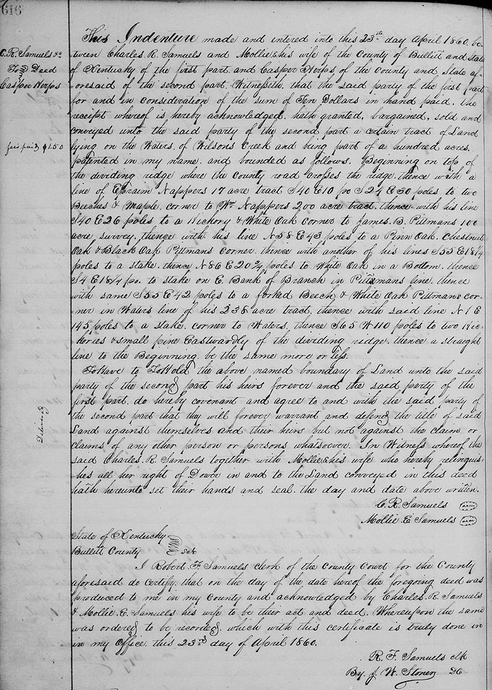
Bullitt County Deed Book O, Pages 616
This indenture made and entered into this 23rd day, April 1860 between Charles R. Samuels and Mollie, his wife, of the county of Bullitt and state of Kentucky of the first part and Casper Herps of the county and state aforesaid of the second part. Witnesseth that the said party of the first part for and in consideration of the sum of $10 in hand paid, the receipt whereof is hereby acknowledged, hath granted, bargained, sold, and conveyed unto the said party of the second part a certain tract of land lying on the waters of Wilson's Creek, and being part of 100 acres patented in my name, and bounded as follows.
Beginning on top of the dividing ridge where the county road crosses the ridge, thence with a line of Ephraim Napper's 17 acre tract S 40° E 10 poles, S 24° E 30 poles to two beeches and maple, corner to William Napper's 200 acre tract, thence with his line S 40° E 26 poles to a hickory and white oak, corner to James B. Pittman's 100 acre survey, thence with his line N 58° E 43 poles to a pin oak, chestnut oak and black oak, Pittman's corner, thence with another of his lines S 55° E 18 1/4 poles to a stake, thence N 86° E 20 3/4 poles to white oak in a bottom, thence S 4° E 18 1/4 poles to a stake on east bank of branch in Pittman's line, thence with same S 55° E 42 poles to a forked beech and white oak, Pittman's corner in Water's line of his 238 acre tract, thence with said line N 1° E 145 poles to a stake, corner to Waters, thence S 65° W 110 poles to two hickories and small pine eastwardly of the dividing ridge, thence a straight line to the beginning, be the same more or less.
To have, and to hold the above named boundary of land unto the said party of the second part, his heirs forever, and the said party of the first part, do hereby covenant, and agreed to, and with the said party of the second part that they will forever warrant and defend the title of said land against themselves, and their heirs, but not against the claim or claims of any other person or persons whatsoever. In witness whereof the said Charles R Samuels together with Mollie, his wife, who hereby relinquishes all her right of dower in and to the land conveyed in this deed, hath hereunto set their hands and seal the day and date above written.
(signed) C. R. Samuels, Mollie E. Samuels
If you, the reader, have an interest in any particular part of our county history, and wish to contribute to this effort, use the form on our Contact Us page to send us your comments about this, or any Bullitt County History page. We welcome your comments and suggestions. If you feel that we have misspoken at any point, please feel free to point this out to us.
The Bullitt County History Museum, a service of the Bullitt County Genealogical Society, is located in the county courthouse at 300 South Buckman Street (Highway 61) in Shepherdsville, Kentucky. The museum, along with its research room, is open 10 a.m. to 4 p.m. Monday through Friday. Saturday appointments are available by calling 502-921-0161 during our regular weekday hours. Admission is free. The museum, as part of the Bullitt County Genealogical Society, is a 501(c)3 tax exempt organization and is classified as a 509(a)2 public charity. Contributions and bequests are deductible under section 2055, 2106, or 2522 of the Internal Revenue Code. Page last modified: 12 Sep 2024 . Page URL: bullittcountyhistory.org/bchistory/samuels-herps.html