
On 9 Oct 1809, Thomas Saunders sold 222 acres to Thomas Wells that lay on the waters of Cedar Creek, a tributary of Floyd's Fork. The deed is transcribed below.
Bullitt County Deed Book B, Page 408-409
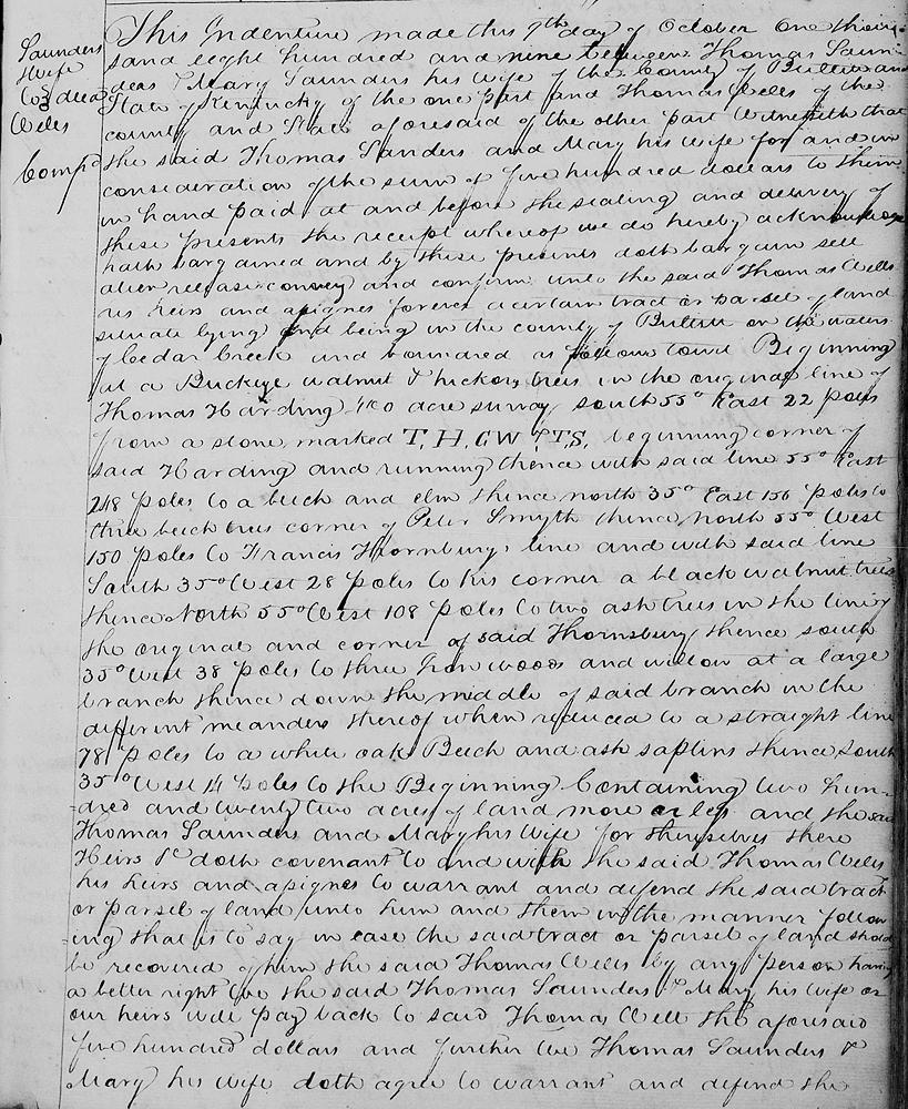
This indenture made this 9th day of October 1809 between Thomas Saunders and Mary Saunders his wife of the County of Bullitt and State of Kentucky of the one part and Thomas Wells of the county and state aforesaid of the other part. Witnesseth that the said Thomas Saunders and Mary his wife for an in consideration of the sum of $500 to them in hand paid at and before the sealing and delivery of these presents, the receipt whereof we do hereby acknowledge, hath bargained and by these presents doth bargain, sell, alien, release, convey and confirm unto the said Thomas Wells, his heirs and assigns forever, a certain tract or parcel of land situate lying and being in the County of Bullitt on the waters of Cedar Creek and bounded as follows, to wit.
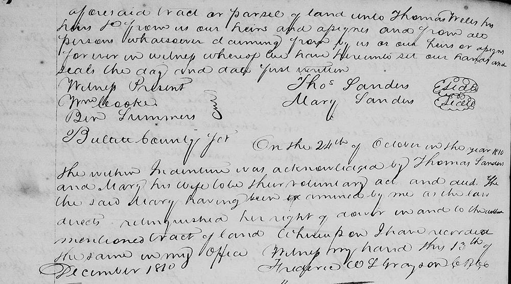
Beginning at a buckeye, walnut and hickory trees in the original line of Thomas Harding's 400 acre survey, South 55° East 22 poles from a stone marked T.H.C.W.P.T.S., beginning corner of said Harding and running thence with said line [] 55° East 248 poles to a beech and elm, thence North 35° East 156 poles to three beech trees, corner of Peter Smyth, thence North 55° West 150 poles to Francis Thornberry's line and with said line South 35° West 28 poles to his corner, a black walnut tree, thence North 55° West 108 poles to two ash trees in the line of the original and corner of said Thornberry, thence South 35° West 38 poles to three iron woods and willow at a large branch, thence down the middle of said branch in the different meanders thereof when reduced to a straight line 78 poles to a white oak, beech and ash saplings, thence South 35° West 14 poles to the beginning containing 222 acres of land, more or less, and the said Thomas Saunders and Mary his wife for themselves, their heirs and assigns to warrant and defend the said tract or parcel of land unto him and them in the manner following, that is to say in case the said tract or parcel of land should be recovered of him the said Thomas Wells by any person having a better right, we the said Thomas Saunders and Mary his wife or our heirs will pay back to said Thomas Wells the aforesaid $500 and further we Thomas Saunders and Mary his wife doth agree to warrant and defend the aforesaid tract or parcel of land unto Thomas Wells, his heirs &c from us, our heirs and assigns and from all persons whatsoever claiming from by us or our heirs or assigns forever. In witness whereof we hve hereunto set our hands and seals the day and date first written.
[Signed by Thomas and Mary Saunders; witnessed by William Cooke and Ben Summers; and recorded in the clerk's office on 13 Dec 1810.]
If you, the reader, have an interest in any particular part of our county history, and wish to contribute to this effort, use the form on our Contact Us page to send us your comments about this, or any Bullitt County History page. We welcome your comments and suggestions. If you feel that we have misspoken at any point, please feel free to point this out to us.
The Bullitt County History Museum, a service of the Bullitt County Genealogical Society, is located in the county courthouse at 300 South Buckman Street (Highway 61) in Shepherdsville, Kentucky. The museum, along with its research room, is open 10 a.m. to 4 p.m. Monday through Friday. Saturday appointments are available by calling 502-921-0161 during our regular weekday hours. Admission is free. The museum, as part of the Bullitt County Genealogical Society, is a 501(c)3 tax exempt organization and is classified as a 509(a)2 public charity. Contributions and bequests are deductible under section 2055, 2106, or 2522 of the Internal Revenue Code. Page last modified: 12 Sep 2024 . Page URL: bullittcountyhistory.org/bchistory/saunders-wells.html