
In 1845, there was still land in Bullitt County that had not been claimed by anyone. In May, Jacob W. Bowman applied for a Vacant Land Warrant for land on both sides of Magruder Creek, a tributary of Long Lick Creek. What follows are images and transcriptions of the various documents associated with that transaction.
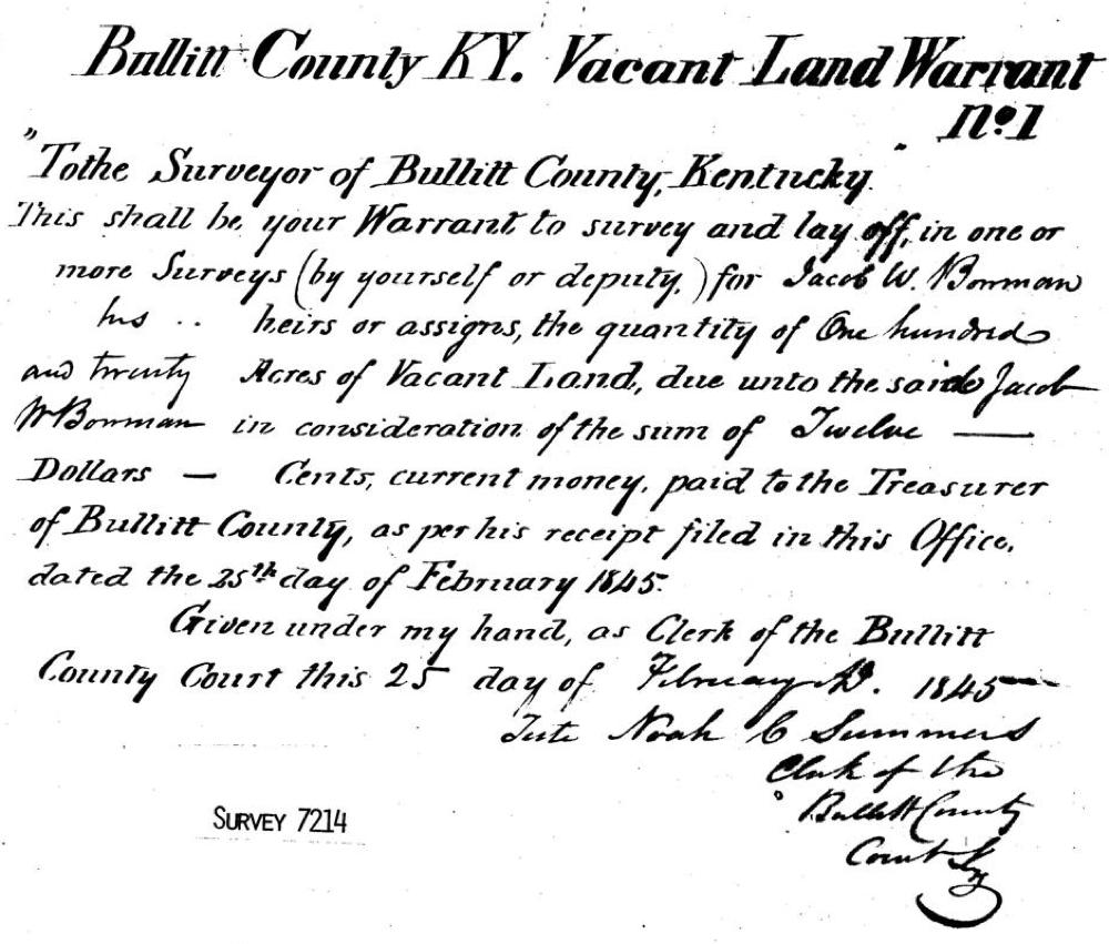
Bowman's first task was to obtain the warrant, which he did from the County Court Clerk Noah Summers, as noted below.
Bullitt County KY Vacant Land Warrant No. 1
"To the Surveyor of Bullitt County, Kentucky"
This shall be your warrant to survey and lay off in one or more surveys (by yourself or deputy) for Jacob W. Bowman, his heirs or assigns, the quantity of one hundred and twenty acres of Vacant Land, due unto the said Jacob W. Bowman in consideration of the sum of twelve dollars - cents, current money, paid to the Treasurer of Bullitt County, as per his receipt filed in this Office dated the 25th day of February 1845.
Given under my hand, as Clerk of the Bullitt County Court, this 25th day of February 1845.
Teste
Noah C. Summers
Clerk of the Bullitt County Court.
Bowman's next step was to take the warrant to the County Surveyor, and make application for the survey, as shown below.
Application of Jacob W. Bowman at the Surveyors Office in Bullitt County, Ky., he having procured a Bullitt County, Ky. Vacant Land Warrant No. 1 for one hundred and twenty acres; said Jacob W. Bowman, by virtue of said Warrant, enters one hundred and twenty acres of Land in Bullitt County on the waters of Long Lick Creek and Crooked Creek, being the supposed amount of Vacant Land lying between the following Surveys, and by which it is bounded as follows: viz. Beginning a t the North East of James Samuels' 280 acre Survey which calls for two beeches in Adam Shepherd's line of his 200 acre Survey, thence with said Shepherd's line N 70 E -- poles to the intersection of a line of Charles Boone's 100 acre Survey [which was patented to Ben. Stansberry,] thence with said Boone's line S70 E -- poles to said Boone's corner of a beech, ash & poplar, in the third line of Paul Froman's 938 acre Survey, thence with his line [Froman's], reversing the same, S 5 E -- poles to said Froman's S. W. Corner which calls for two white oaks in the Knobs, in a line of Mathew Walton's 5934 acre survey, thence with said Walton's line S 85 W -- poles to said Jas Samuels' S. E. corner of his 280 acre Survey, which calls to be in said Walton's line of a white oak, thence with the line of said Samuels North 170 poles to the Beginning.
(signed) L. E. Schultz, S.B.C.
February 25th 1845
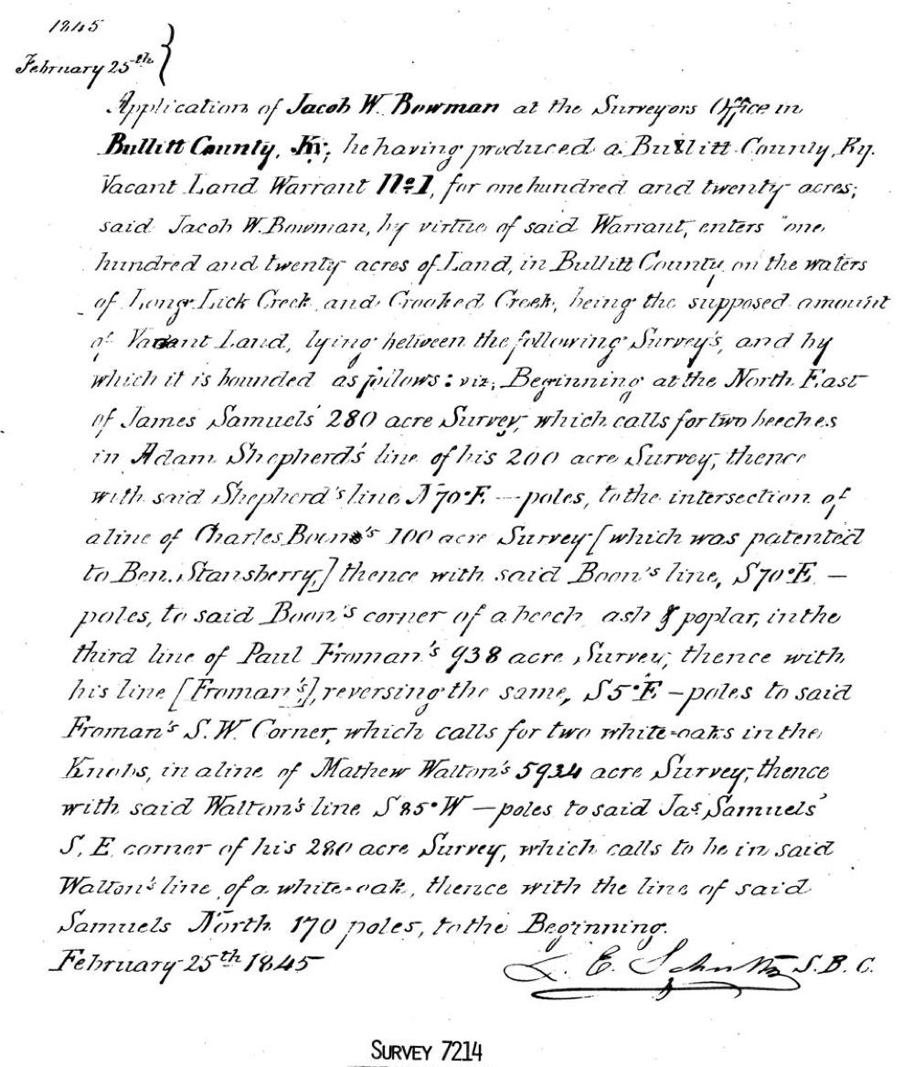
This document outlined the general location of the proposed survey, minus some specific measurements.
It appears that Schultz, the County Surveyor, deputized Bowman to perform the survey, as we will see in the next document, the actual survey.
Surveyed for Jacob W. Bowman, One hundred and fourteen acres of Land lying in Bullitt County Ky on both sides of Magruders Run, waters of Long Lick Creek, South Side of Salt River, by virtue of an entry made the 25th day of February 1845 on a Bullitt County Ky. Vacant Land Warrant No. 1 for 120 acres, which Survey is bounded as follows: Beginning at a black oak, dogwood, and maple saplings (at A) on Slate Knob whre the original N E corner of James Samuels 280 acre Survey of two beeches is Supposed to have been in Adam Shepherd's line of his 200 acre survey, thence with said Shepherd's line N 71 East (for 70) 43 3/4 poles to a Sweet gum, hickory, and black oak saplings in Charles Boone's line of his 100 acre Survey which was patented to Benjamin Stansberry, thence with said Boone's or Stansberry line S 70 E 32 poles to a beech in Paul Froman's line of his 938 acre Survey where the original S E corner of said Stansberry's a beech, poplar and ash is supposed to have been, thence with said Froman's line S 4 degrees 18 minutes East (for 5 degrees) 230 poles to said Froman's South West corner of two white oaks on a Knob (one down) in a line of Matthew Walton's 5934 acre survey, thence with said Walton's line N 82 West (for S 85 W) 92 poles to two white oaks and two black oaks on the side of a Knob where said Samuels' S E corner of a white oak is supposed to have been, thence with said Samuels' line N 1 East (for North) 213 1/4 poles (for 170 poles) to the place of beginning.
We the undersigned, being Housekeepers of Bullitt County attended to the Execution of the above Survey, having been duly sworn, given under our hands and seals this 9th day of May 1845.
(signed)
G. W. Maraman, Wm Shirley, C.C.
Jacob W. Bowman, Conductor of the Survey
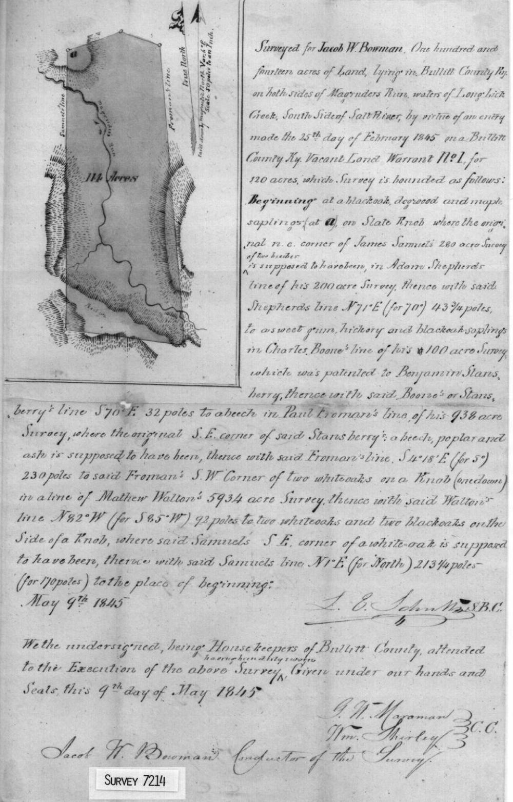
From this we know that Jacob Bowman conducted the survey, and that Maraman and Shirley were the chain carriers.
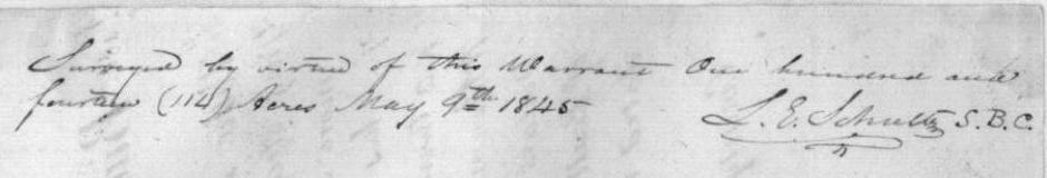
To verify the survey, Schultz wrote on the back of the warrant the statement, "Surveyed by virtue of this warrant one hundred and fourteen (114) acres, May 9th 1845. (signed) L. E. Schultz, S.B.C."
Next, Bowman wrote on the back of the survey, "For value received, I assign the within survey of 114 acres, without recourse, to L. E. Schultz. (signed) J. W. Bowman (date) May the 30th 1845."
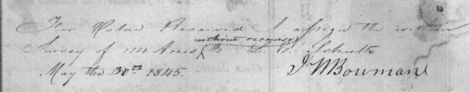
It is not yet clear whether Bowman and Schultz had a previous arrangement regarding this land, or if Bowman agreed to sell it to Schultz after the fact. However, the land was deeded to Schultz, as shown below.
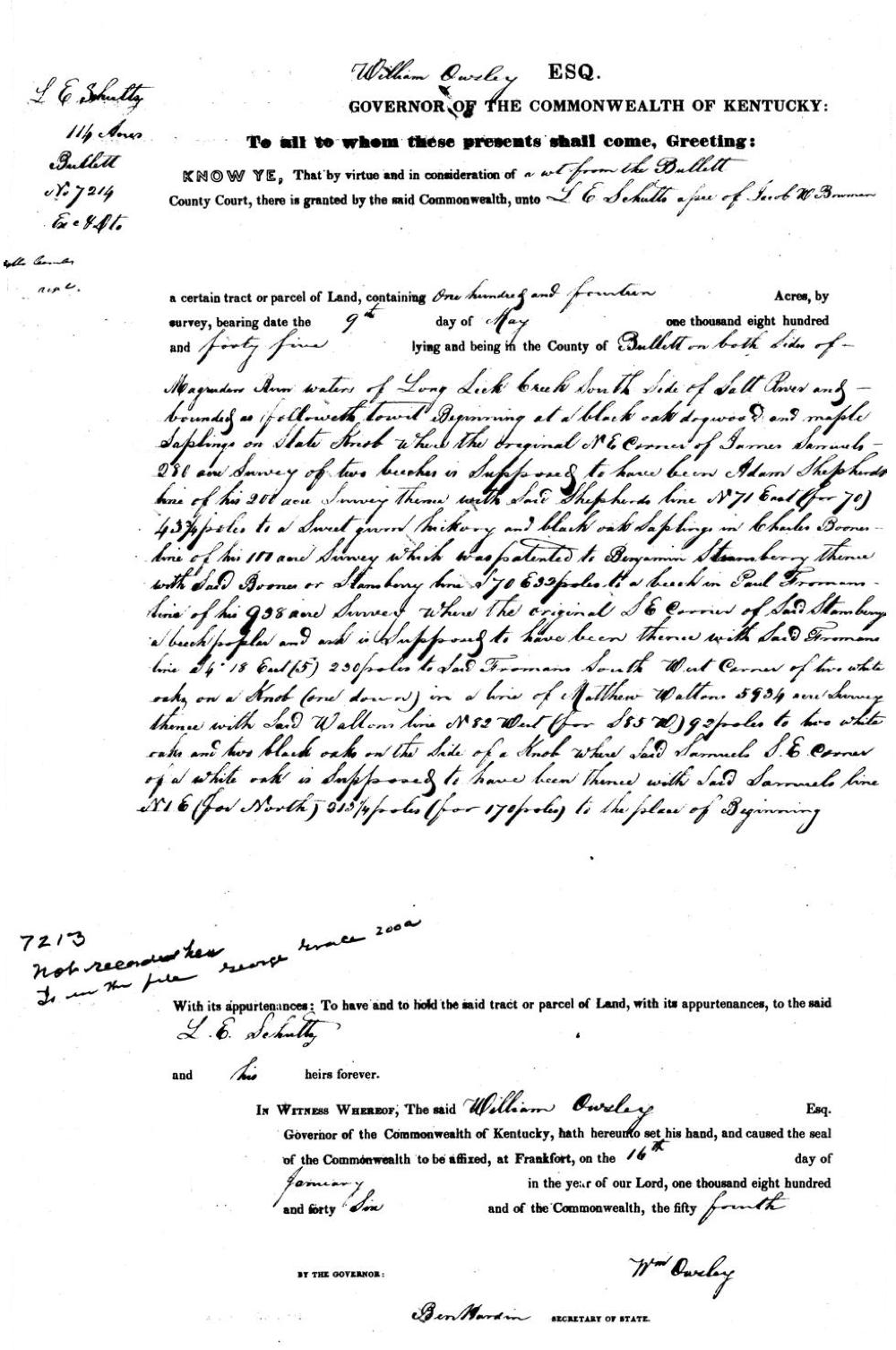
William Owsley, Esq., Governor of the Commonwealth of Kentucky:
To all to whom these presents shall come, Greeting:
Knew ye, That by virtue and in consideration of a writ from the Bullitt County Court, there is granted by the said Commonwealth, unto L. E. Schultz, assignee of Jacob W. Bowman, a certain tract or parcel of Land, containing one hundred and fourteen Acres, by survey, bearing date the 9th day of May, one thousand eight hundred and forty five, lying and being in the County of Bullitt on both sides of Magruder Run waters of Long Lick Creek, South Side of Salt River and bounded as followeth, towit, Beginning at a black oak, dogwood, and maple saplings (at A) on Slate Knob whre the original N E corner of James Samuels 280 acre Survey of two beeches is Supposed to have been in Adam Shepherd's line of his 200 acre survey, thence with said Shepherd's line N 71 East (for 70) 43 3/4 poles to a Sweet gum, hickory, and black oak saplings in Charles Boone's line of his 100 acre Survey which was patented to Benjamin Stansberry, thence with said Boone's or Stansberry line S 70 E 32 poles to a beech in Paul Froman's line of his 938 acre Survey where the original S E corner of said Stansberry's a beech, poplar and ash is supposed to have been, thence with said Froman's line S 4 degrees 18 minutes East (for 5 degrees) 230 poles to said Froman's South West corner of two white oaks on a Knob (one down) in a line of Matthew Walton's 5934 acre survey, thence with said Walton's line N 82 West (for S 85 W) 92 poles to two white oaks and two black oaks on the side of a Knob where said Samuels' S E corner of a white oak is supposed to have been, thence with said Samuels' line N 1 East (for North) 213 1/4 poles (for 170 poles) to the place of beginning. With its appurtenances: To have and to hold the said tract or parcel of Land, with its appurtenances, to the said L. E. Schultz and his heirs forever.
In Witness Whereof, the said William Owsley Esq., Governor of the Commonwealth of Kentucky, hath hereunto set his hand, and caused the seal of the Commonwealth to be affixed, at Frankfort on the 16th day of January, in the year of our Lord, one thousand eight hundred and forty six, and of the Commonwealth the fifty fourth.
(signed) Wm Owsley, Governor; Ben Hardin, Secretary of State
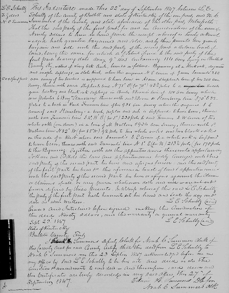
And thus was concluded what appears to have been the first official Vacant Land Warrant in Bullitt County. However, Schultz soon after, in September 1847, sold the tract to N. C. Summers as shown below and in Bullitt County Deed Book L, page 164.
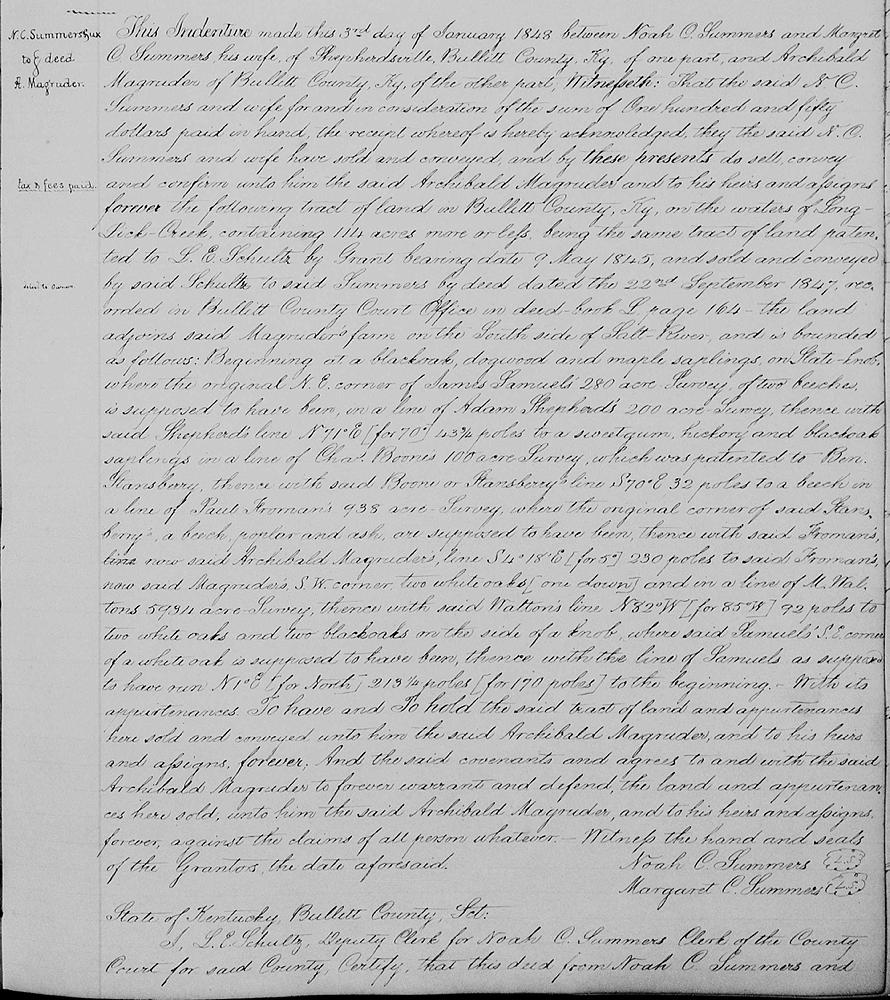
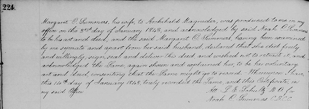
Then the following January, Summers sold the tract to Archibald Magruder [Bullitt County Deed Book L, page 223] who owned the adjoining land to the east. That deed is shown below.
If you, the reader, have an interest in any particular part of our county history, and wish to contribute to this effort, use the form on our Contact Us page to send us your comments about this, or any Bullitt County History page. We welcome your comments and suggestions. If you feel that we have misspoken at any point, please feel free to point this out to us.
The Bullitt County History Museum, a service of the Bullitt County Genealogical Society, is located in the county courthouse at 300 South Buckman Street (Highway 61) in Shepherdsville, Kentucky. The museum, along with its research room, is open 10 a.m. to 4 p.m. Monday through Friday. Saturday appointments are available by calling 502-921-0161 during our regular weekday hours. Admission is free. The museum, as part of the Bullitt County Genealogical Society, is a 501(c)3 tax exempt organization and is classified as a 509(a)2 public charity. Contributions and bequests are deductible under section 2055, 2106, or 2522 of the Internal Revenue Code. Page last modified: 12 Sep 2024 . Page URL: bullittcountyhistory.org/bchistory/vacant-land.html