
In 1843, a group of men, including Abraham Chappell, William F. Chappell, John W. Goheen, William Stibbins, James Arnold and Richard Skinner, purchased a half share (1000 acres) of Robert Sanford's 2000 acre patent from Nathaniel Pope who was living in Illinois at the time. We have not yet determined how Pope obtained this land.
According to the deed shown below, George W. Miles obtained John W. Goheen's share, and Abraham Chappell obtained William F. Chappell's share. Then in 1845, 98 acres of the tract was deeded to George W. Miles by the others, as shown below.
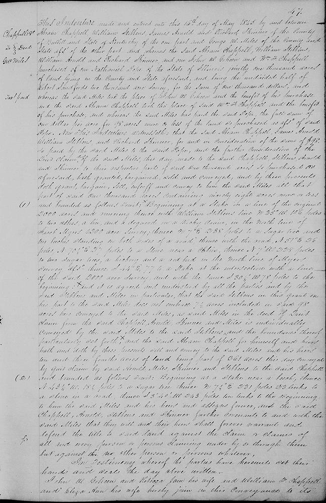
Bullitt County Deed Book L, Pages 47-48
This indenture made and entered into this 16th day of May 1845 by and between Abram Chappell, William Stibbins, James Arnold and Richard Skinner of the county of Bullitt and state of Kentucky of the one part and George W. Miles of the county and state aforesaid of the other part, and whereas the said Abram Chappell, William Stibbins, James Arnold and Richard Skinner, and one John W. Goheen and William F. Chappell purchased of one Nathaniel Pope of the state of Illinois jointly 1000 acres of land lying in the county and state aforesaid, and being the undivided half of Robert Sandford's 2000 acre survey, for the sum of $1000, and whereas the said Miles took the place of John W. Goheen and the benefit of his purchase, and the said Abram Chappell took the place of said William F. Chappell and the benefit of his purchase, and whereas the said Miles has paid the said Pope the full sum of one dollar per acre for 98 acres more or less of the land so purchased as aforesaid of said Pope.
Now this indenture witnesseth that the said Abram Chappell, James Arnold, William Stibbins and Richard Skinner for and in consideration of the sum of $98 so paid by the said Miles to the said Pope, and the further consideration of the quit claim deed of the said Miles this day made to the said Chappell, Stibbins, Arnold and Skinner to their respective parts of said 1000 acres so purchased as aforesaid, hath granted, bargained, sold and conveyed, and by these presents doth grant, bargain, sell, enfeoff and convey to him the said Miles all that part of said 1000 acres containing 98 acres more or less, and bounded as follows, to wit.
Beginning at a stake in a line of the original 2000 acres and running thence with William Stibbins' line N 35° W 106 poles to two ashes, a lin, and a dogwood on a rocky drain in the north line of Jacob Myers' 1200 acre survey, thence N 7° E 238 poles to a sugar tree and two beeches standing on both sides of a road, thence with the road N 57° E 26 poles, N 70 1/2° E 27 poles to a stone near a cabin, thence N 7° W 228 poles to two sugar trees, a hickory and a redbud in the north line of Myers' survey aforesaid, thence S 44° E 77 to a stake at the intersection with a line of the said 2000 acre survey and with the same S 30 1/4° W 78 poles to the beginning.
And it is agreed and understood by all the parties and by the said Stibbins and Miles in particular that the said Stibbins in this grant on his part to the said Miles does not embrace 7 1/2 acres included in said 98 acres here conveyed to the said Miles, as said Miles in the deed of quick claim from the said Chappell, Arnold, Skinner and Miles is individually conveyed by the said Miles to the said Stibbins, and the boundaries thereof particularly set forth, and the said Abram Chappell for himself and heirs hath and doth by these presents sell and convey to the said Miles and his heirs 10 3/4 acres of land being part of 261 acres this day conveyed by quit claim by said Arnold, Miles, Skinner and Stibbins to the said Chappell and bounded as follows, to wit.
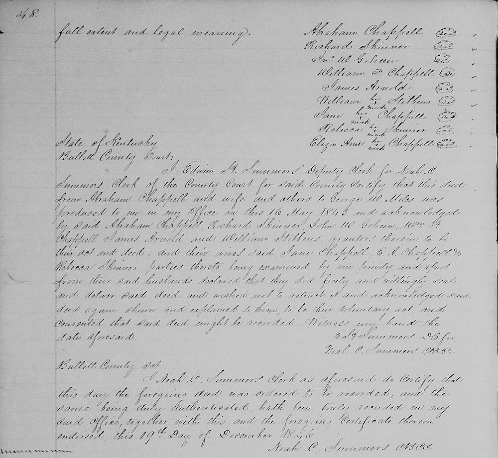
Beginning at a stake near a beech, thence N 43 1/4° W 18 1/2 poles to a sugar tree, thence N 7 1/2° E 231 poles 23 links to a stone in a road, thence S 3°40' W 243 poles 10 links to the beginning to him the said Miles and his heirs and assigns forever, and the said Chappell, Arnold, Stibbins and Skinner further covenants to and with the said Miles that they will and their heirs shall forever warrant and defend the title to said land against the claim or claims of all and every person or persons claiming under, by ort through them, but against no other person or persons whatever. In testimony whereof the parties have hereunto set their hands and seals the day above written. John W. Goheen and Rebecca Jane his wife and William F. Chappell and Eliza Ann his wife hereby join in this conveyance to its full extent and legal meaning. (Signed by all parties.)
If you, the reader, have an interest in any particular part of our county history, and wish to contribute to this effort, use the form on our Contact Us page to send us your comments about this, or any Bullitt County History page. We welcome your comments and suggestions. If you feel that we have misspoken at any point, please feel free to point this out to us.
The Bullitt County History Museum, a service of the Bullitt County Genealogical Society, is located in the county courthouse at 300 South Buckman Street (Highway 61) in Shepherdsville, Kentucky. The museum, along with its research room, is open 10 a.m. to 4 p.m. Monday through Friday. Saturday appointments are available by calling 502-921-0161 during our regular weekday hours. Admission is free. The museum, as part of the Bullitt County Genealogical Society, is a 501(c)3 tax exempt organization and is classified as a 509(a)2 public charity. Contributions and bequests are deductible under section 2055, 2106, or 2522 of the Internal Revenue Code. Page last modified: 12 Sep 2024 . Page URL: bullittcountyhistory.org/bchistory/group-miles.html