
On 27 Feb 1871, Jilson and Chaddie Johnson sold two tracts, one of 212 acres and the other of about 11 acres of land on the north side of Salt River on Floyd's Fork and Cedar Creek to Mary Tyler. This tract included the 212 acres deeded to Chaddie Johnson by Augustin & Sarah Moreman.
Bullitt County Deed Book S, pages 278-282
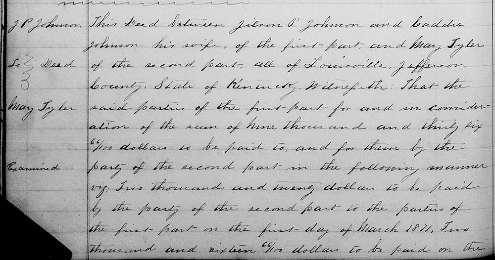
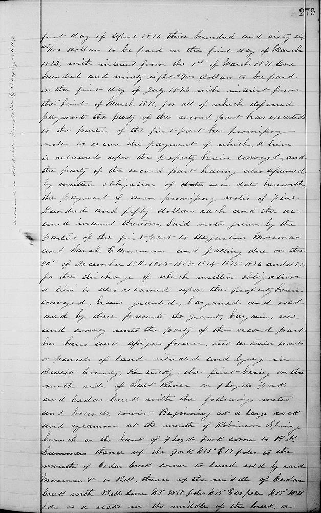
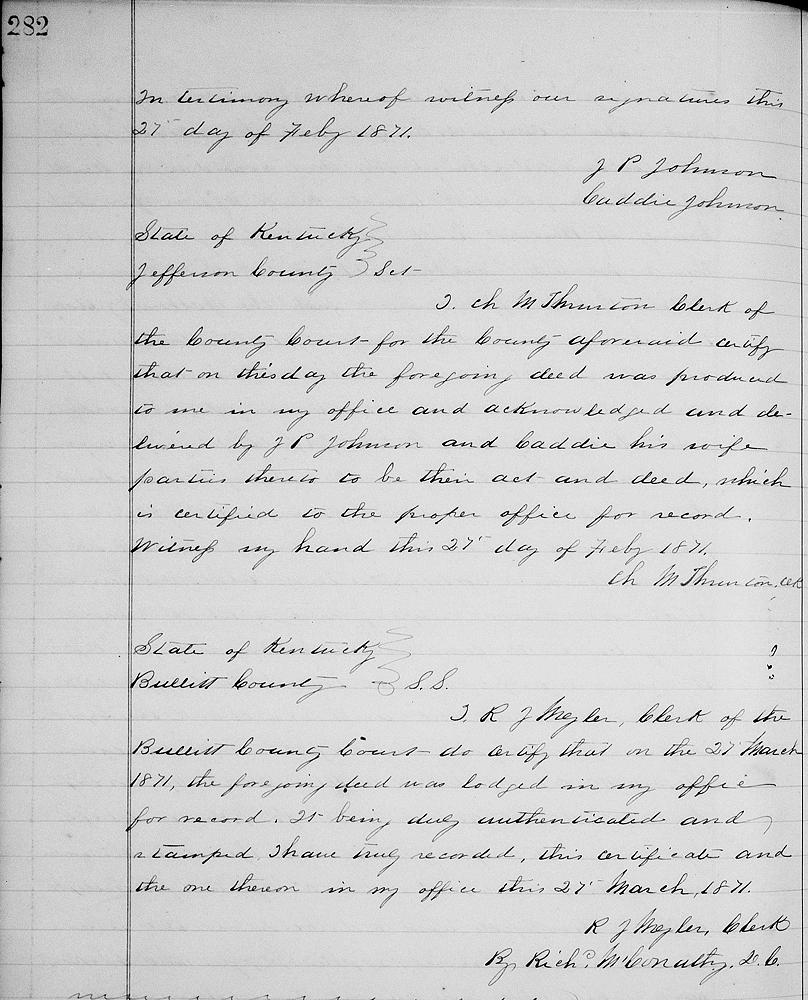
This deed between Jilson P. Johnson and Caddie Johnson his wife of the first part and Mary Tyler of the second part, all of Louisville, Jefferson County, state of Kentucky. Witnesseth that the said parties of the first part for and in consideration of the sum of $9,036.66 to be paid to and for them by the party of the second part in the following manner, viz. $2,020 to be paid by the party of the second part to the parties of the first part on the first day of March 1871, $2,016.66 to be paid on the first day of April 1871, $366.42 to be paid on the first day of March 1872 with interest from the 1st of March 1871, $198.48 to be paid on the first day of July 1872 with interest from the first of March 1871, for all of which deferred payments the party of the second part has executed to the parties of the first part her promissory notes to secure the payment of which a lien is retained upon the property herein conveyed, and the party of the second part having also assumed by written obligation of even date herewith the payment of seven promissory notes of $555 each and the accrued interest thereon, said notes given by the parties of the first part to Augustin Moreman and Sarah E. Moreman and falling due on the 30th of December 1871, 1872, 1873, 1874, 1875, 1876 and 1877, for the discharge of which written obligation a lien is also retained upon the property herein conveyed, have granted, bargained and sold and by these presents do grant, bargain, sell and convey unto the party of the second part, her heirs and assigns forever two certain tracts or parcels of land situated and lying in Bullitt County, Kentucky, the first being on the north side of Salt River on Floyd's Fork and Cedar Creek with the following metes and bounds, to wit.
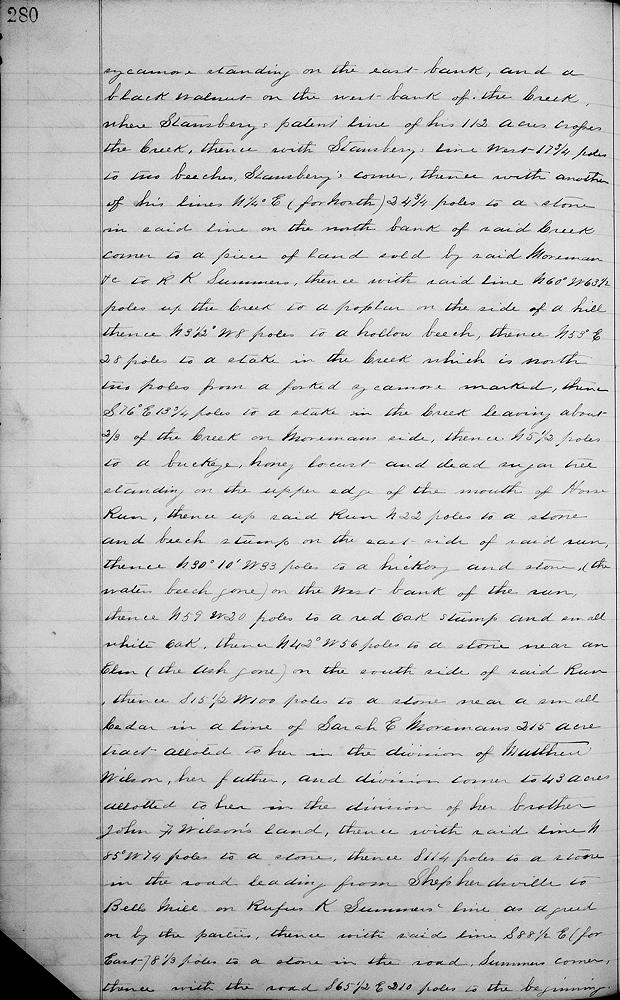
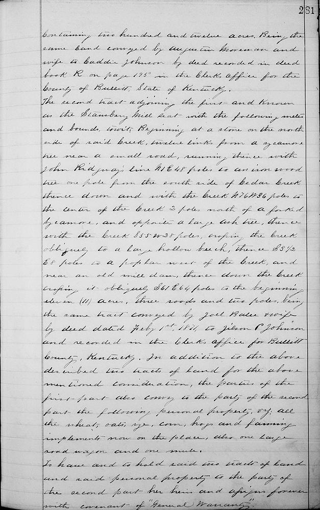
Beginning at a large rock and sycamore at the mouth of Robinson Spring branch on the bank of Floyd's Fork, corner to R. K. Summers, thence up the Fork N 15° E 19 poles to the mouth of Cedar Creek, corner to land sold by said Moreman &c to Bell, thence up the middle of Cedar Creek with Bell's line N 3° W 18 poles, N 15° E 48 poles, N 15° W 21 poles to a stake in the middle of the creek, a sycamore standing on the east bank, and a black walnut on the west bank of the creek where Stansbury's patent line of his 112 acres crosses the creek, thence with Stansbury's line West 17 3/4 poles to two beeches, Stansbury's corner, thence with another of his lines N 1/4° E (for North) 24 3/4 poles to a stone in said line on the north bank of said creek, corner to a piece of land sold by said Moreman &c to R. K. Summers, thence with said line N 60° W 63 1/2 poles up the creek to a poplar on the side of a hill, thence N 3 1/2° W 8 poles to a hollow beech, thence N 53° E 28 poles to a stake in the creek which is north two poles from a forked sycamore marked, thence S 76° E 18 3/4 poles to a stake in the creek, leaving about 2/3 of the creek on Moreman side, thence North 5 1/2 poles to a buckeye, honey locust and dead sugar tree standing on the upper edge of the mouth of Horse Run, thence up said Run North 22 poles to a stone and beech stump on the east side of said Run, thence N 30°10' W 33 poles to a hickory and stone, (the water beech gone) on the west bank of the Run, thence N 59° W 20 poles to a red oak stump and small white oak, thence N 42° W 56 poles to a stone near to an elm (the ash gone) on the south side of said Run, thence S 15 1/2° W 100 poles to a stone near a small cedar in a line of Sarah E. Moreman's 215 acre tract allotted to her in the division of Matthew Wilson, her father, and division corner to 43 acres allotted to her in the division of her brother John F. Wilson's land, thence with said line N 85° W 74 poles to a stone, thence South 114 poles to a stone in the road leading from Shepherdsville to Bell's mill in Rufus K. Summer's line as agreed on by the parties, thence with said line S 88 1/2° E (for East) 8 1/3 poles to a stone in the road, Summer's corner, thence with the road S 65 1/2° E 210 poles to the beginning, containing 212 acres, being the same land conveyed by Augustin Moreman and wife to Caddie Johnson by deed recorded in Deed Book R on page 195 in the clerk's office for the County of Bullitt, State of Kentucky.
The second tract adjoining the first and known as the Stansbury mill seat with the following metes and bounds, to wit. Beginning at a stone on the north side of said creek, 12 links from a sycamore tree near a small road, running thence with John Ridgway's line N 1° E 48 poles to an ironwood tree one pole from the south side of Cedar Creek, thence down and with the creek N 76° W 36 poles to the center of the creek, 2 poles north of a forked sycamore and opposite a large ash tree, thence with the creek S 55° W 28 poles, crossing the creek obliquely to a large hollow beech, thence S 3 1/2° E 8 poles to a poplar west of the creek, and near an old mill dam, thence down the creek, crossing it obliquely S 61° E 64 poles to the beginning; eleven acres, three roods and two poles, being the same tract conveyed by Joel Balee and wife by deed dated February 1st 1871, to Jilson P. Johnson and recorded in the clerk's office for Bullitt County, Kentucky.
In addition to the above described two tracts of land for the above mentioned consideration, the parties of the first part also convey to the party of the second part the following personal property, viz. all the wheat, oats, rye, corn, hogs and farming implements now on the place, also one large road wagon and one mule.
To have and to hold said two tracts of land and said personal property to the party of the second part, her heirs and assigns forever with covenant of "general warranty." In testimony whereof witness our signatures this 27th day of February 1871. (signed) J. P. Johnson, Caddie Johnson.
If you, the reader, have an interest in any particular part of our county history, and wish to contribute to this effort, use the form on our Contact Us page to send us your comments about this, or any Bullitt County History page. We welcome your comments and suggestions. If you feel that we have misspoken at any point, please feel free to point this out to us.
The Bullitt County History Museum, a service of the Bullitt County Genealogical Society, is located in the county courthouse at 300 South Buckman Street (Highway 61) in Shepherdsville, Kentucky. The museum, along with its research room, is open 10 a.m. to 4 p.m. Monday through Friday. Saturday appointments are available by calling 502-921-0161 during our regular weekday hours. Admission is free. The museum, as part of the Bullitt County Genealogical Society, is a 501(c)3 tax exempt organization and is classified as a 509(a)2 public charity. Contributions and bequests are deductible under section 2055, 2106, or 2522 of the Internal Revenue Code. Page last modified: 12 Sep 2024 . Page URL: bullittcountyhistory.org/bchistory/johnson-tyler.html